'Ayn Fit
عين فيت | |
|---|---|
Village | |
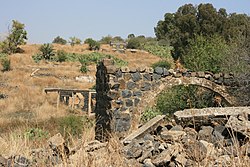
 Ruins at 'Ayn Fit | |
| Coordinates: 33°13′26″N 35°42′15″E / 33.22389°N 35.70417°E | |
| Country | |
| Governorate | Quneitra |
| District | Quneitra |
| Region | Golan Heights |
| Founded | 17th century |
| Destroyed | 1967 |
| Population (1960s) | |
| • Total | 1,500 (estimate) |
'Ayn Fit (Arabic: عين فيت), was a Syrian Alawite village situated in the northwestern Golan Heights.[1][2]
- ^ Abu Fakhr, Sakr (2000). "Voices from the Golan". Journal of Palestine Studies. 29 (4): 5–36. doi:10.2307/2676559. JSTOR 2676559.
- ^ Southern Lebanon Border Area 1986 – Map from the University of Texas at Austin general libraries map collection, showing 'Ayn Fit
