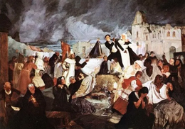
 "Terremoto de 1812", painting by Tito Salas | |
| Local date | March 26, 1812 |
|---|---|
| Local time | 16:37 |
| Magnitude | 7.7 M[1] |
| Depth | 33 km (21 mi)[1] |
| Epicenter | 10°36′N 66°54′W / 10.6°N 66.9°W[1] |
| Max. intensity | MMI X (Extreme)[1] |
| Casualties | 15,000–20,000 fatalities |
The 1812 Caracas earthquake took place in Venezuela on March 26 (on Maundy Thursday) at 4:37 p.m. It measured 7.7 on the Richter scale.[citation needed] It caused extensive damage in Caracas, La Guaira, Barquisimeto, San Felipe, and Mérida. An estimated 15,000–20,000 people perished as a result, in addition to incalculable material damage.[citation needed]
The seismic movement was so significant that in a zone named Valecillo, a new lake was formed and the river Yurubí was dammed up. Numerous rivulets changed their course in the Caracas valley, which was flooded with dirty water. [citation needed]
Based on contemporary descriptions, the earthquake is believed to have consisted of two seismic shocks occurring within the span of 30 minutes.[citation needed] The first destroyed Caracas and the second Mérida, where it was raining when the shock occurred.
- ^ a b c d National Geophysical Data Center / World Data Service (NGDC/WDS): NCEI/WDS Global Significant Earthquake Database. NOAA National Centers for Environmental Information (1972). "Significant Earthquake Information". NOAA National Centers for Environmental Information. doi:10.7289/V5TD9V7K. Retrieved July 26, 2022.

