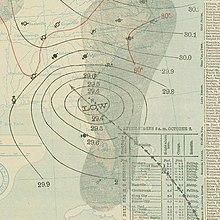
 Surface weather analysis of the hurricane on October 2 | |
| Meteorological history | |
|---|---|
| Formed | September 25, 1898 |
| Dissipated | October 6, 1898 |
| Category 4 major hurricane | |
| 1-minute sustained (SSHWS/NWS) | |
| Highest winds | 130 mph (215 km/h) |
| Lowest pressure | 938 mbar (hPa); 27.70 inHg |
| Overall effects | |
| Fatalities | At least 179 |
| Damage | $1.5 million (1898 USD) |
| Areas affected | Georgia (landfall), Florida, Midwestern United States Atlantic Canada |
| IBTrACS | |
Part of the 1898 Atlantic hurricane season | |
The 1898 Georgia hurricane was a major hurricane that hit the U.S. state of Georgia, as well as the strongest on record in the state. It was first observed on September 29, although modern researchers estimated that it developed four days earlier to the east of the Lesser Antilles. The hurricane maintained a general northwest track throughout its duration, and it reached peak winds of 130 mph (210 km/h) on October 2. That day, it made landfall on Cumberland Island in Camden County, Georgia, causing record storm surge flooding. The hurricane caused heavy damage throughout the region, and killed at least 179 people. Impact was most severe in Brunswick, where a 16 ft (4.9 m) storm surge was recorded. Overall damage was estimated at $1.5 million (1898 USD), most of which occurred in Georgia. In extreme northeastern Florida, strong winds nearly destroyed the city of Fernandina, while light crop damage was reported in southern South Carolina. After moving ashore, the hurricane quickly weakened and traversed much of North America; it continued northwestward until reaching the Ohio Valley and turning northeastward, and it was last observed on October 6 near Newfoundland.