| UTC time | 1911-01-03 23:25:48 |
|---|---|
| ISC event | 16958130 |
| USGS-ANSS | ComCat |
| Local date | 4 January 1911 |
| Local time | 05:25 |
| Magnitude | 8.0 Mw 8.1 Ms |
| Depth | 20 km (12 mi) |
| Epicenter | 42°54′N 76°48′E / 42.9°N 76.8°E |
| Areas affected | Kyrgyzstan, Kazakhstan |
| Total damage | Severe[1] |
| Max. intensity | MMI X (Extreme)[1] |
| Casualties | 452 dead, 740 injured |

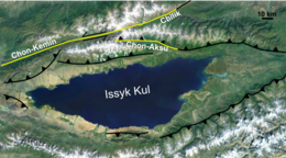
The 1911 Kebin earthquake, or Chon-Kemin earthquake, struck Russian Turkestan on 3 January. Registering at a moment magnitude of 8.0, it killed 452 people, destroyed more than 770 buildings (which was almost all of the city) in Almaty, Kazakhstan, and resulted in 125 miles (201 km) of surface faulting in the valleys of Chon-Kemin, Chilik and Chon-Aksu.[2]
- ^ a b National Geophysical Data Center / World Data Service (NGDC/WDS): NCEI/WDS Global Significant Earthquake Database. NOAA National Centers for Environmental Information (1972). "Significant Earthquake Information". NOAA National Centers for Environmental Information. doi:10.7289/V5TD9V7K. Retrieved 4 January 2024.
- ^ "Today in Earthquake History: January 3". United States Geological Survey. 27 October 2009. Archived from the original on 23 January 2010. Retrieved 3 January 2010.
