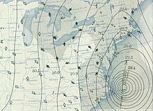
 Weather map from September 21 depicting the storm off the Mid-Atlantic coast | |
| Meteorological history | |
|---|---|
| Formed | September 9, 1938 |
| Extratropical | September 22, 1938 |
| Dissipated | September 23, 1938 |
| Category 5 major hurricane | |
| 1-minute sustained (SSHWS/NWS) | |
| Highest winds | 160 mph (260 km/h) |
| Lowest pressure | <940 mbar (hPa); <27.76 inHg |
| Overall effects | |
| Fatalities | 682 to 800 direct |
| Damage | $306 million (1938 USD) |
| Areas affected | Southeastern United States, Northeastern United States (particularly Connecticut, New York, Rhode Island, and Massachusetts), southwestern Quebec |
| IBTrACS | |
Part of the 1938 Atlantic hurricane season | |
The 1938 New England Hurricane (also referred to as the Great Long Island - New England Hurricane and the Long Island Express Hurricane)[1][2] was one of the deadliest and most destructive tropical cyclones to strike the United States. The storm formed near the coast of Africa on September 9, becoming a Category 5 hurricane on the Saffir–Simpson hurricane scale, before making landfall as a Category 3 hurricane[2] on Long Island on Wednesday, September 21. It is estimated that the hurricane killed 682 people,[3] damaged or destroyed more than 57,000 homes, and caused property losses estimated at $306 million ($4.7 billion in 2024).[4][5][6][7] Also, numerous others estimate the real damage between $347 million and almost $410 million.[8] Damaged trees and buildings were still seen in the affected areas as late as 1951.[9] It remains the most powerful and deadliest hurricane to ever strike New York and New England in history, perhaps eclipsed in landfall intensity only by the Great Colonial Hurricane of 1635.[10]
The storm developed into a tropical depression on September 9 off the coast of West Africa, but the United States Weather Bureau was unaware that a tropical cyclone existed until September 16 when ships reported strong winds and rough seas 350 miles northeast of San Juan; by then, it was already a well-developed hurricane and had tracked westward toward the southeastern Bahamas. It reached hurricane strength on September 15 and continued to strengthen to a peak intensity of 160 mph (260 km/h) near the southeastern Bahamas four days later, making it a Category 5-equivalent hurricane.[note 1] The storm was propelled northward, rapidly paralleling the East Coast before making landfalls on Long Island, New York and Connecticut as a Category 3 hurricane on September 21, with estimated sustained winds of 115–120 mph. After moving inland, it transitioned into an extratropical cyclone and dissipated over Ontario on September 23.
- ^ Voorhees, Josh (October 29, 2012). "Hurricane Sandy Isn't NYC's First Freak Superstorm". Slate Magazine. Retrieved August 23, 2019.
- ^ a b "The Great Hurricane of 1938 - The Long Island Express". Archived from the original on September 25, 2014. Retrieved February 9, 2017.
- ^ Scotti, R. A. "Sudden Sea – The Great Hurricane of 1938". Boston: Little, Brown & Co., 2003. Archived from the original on January 2, 2007. Retrieved November 30, 2007.
- ^ "New England Numbers Hurricane of '38". NewEngland.com. Yankee Magazine. August 19, 2008. Retrieved April 8, 2024.
- ^ Ian Webster. "$306,000,000 in 1938 is worth $6,734,734,468.09 today". CPI Inflation Calculator. Official Data Foundation. Retrieved April 8, 2024.
- ^ An Actuary Reads the Newspaper (PDF). New York Annual Meeting October 18–21, 1998. Record of the Society of Actuaries. Vol. 24, no. 3. Retrieved October 10, 2021.
- ^ Karen M. Clark (November 12, 2017). "A Hurricane Andrew Message for Insurers". Actuarial Review. Retrieved October 10, 2021.
- ^ "Hurricane 1938 Aftermath". The PBS Network. Retrieved October 10, 2021.
- ^ Lane, F. W. (1966). The Elements Rage. p. 16. ISBN 0-8019-5088-0.
- ^ Lefebvre, Paul (October 19, 2016). "How a hurricane changed New England's forests" (PDF). The Chronicle. Barton, Vermont. p. B1.
review of book: 'Thirty-Eight, The Hurricane that Transformed New England', by Stephen Long 2016
- ^ Atlantic Oceanographic and Meteorological Laboratory. "Saffir-Simpson Hurricane Scale". Miami Regional Library. Miami, Florida: National Oceanic and Atmospheric Administration. Retrieved June 15, 2016.
Cite error: There are <ref group=note> tags on this page, but the references will not show without a {{reflist|group=note}} template (see the help page).