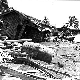
 Tsunami damage at Lebak, Mindanao | |
| UTC time | 1976-08-16 16:11:08 |
|---|---|
| ISC event | 709878 |
| USGS-ANSS | ComCat |
| Local date | August 17, 1976 |
| Local time | 00:11:07 |
| Magnitude | 8.0 Mw |
| Depth | 20 km (12 mi) |
| Epicenter | 6°17′N 124°05′E / 6.29°N 124.09°E[1] |
| Type | Megathrust |
| Areas affected | Philippines |
| Max. intensity | |
| Tsunami | 9 m (30 ft) |
| Casualties | 5,000–8,000 dead
10,000 injured 90,000 homeless |
The 1976 Moro Gulf earthquake and tsunami occurred on August 17, 1976, at 00:11 local time near the islands of Mindanao and Sulu, in the Philippines. It measured 8.0 on the moment magnitude scale occurring at a depth of 20 km (12 mi).[2] The earthquake was accompanied by a destructive tsunami that resulted in a majority of the estimated 5,000 to 8,000 fatalities. It was the deadliest and strongest earthquake in the Philippines in 58 years since the 1918 Celebes Sea earthquake.
- ^ Cite error: The named reference
Engdahlwas invoked but never defined (see the help page). - ^ ISC (2022), ISC-GEM Global Instrumental Earthquake Catalogue (1904–2018), Version 9.1, International Seismological Centre
