 Piles of rubble, one week after the shock | |
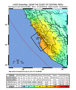
 Map of the Peru coastline, showing location and strength of quake. Star marks epicenter. | |
| UTC time | 2007-08-15 23:40:57 |
|---|---|
| ISC event | 12804735 |
| USGS-ANSS | ComCat |
| Local date | August 15, 2007 |
| Local time | 18:40:57 |
| Magnitude | 8.0 Mw |
| Depth | 39 km (24 mi) |
| Epicenter | 13°21′14″S 76°30′32″W / 13.354°S 76.509°W |
| Type | Megathrust |
| Areas affected | Ica Region (Pisco, Ica and Chincha Alta) and Lima Region (San Vicente de Cañete) |
| Max. intensity | MMI XI (Extreme)[1] |
| Tsunami | flooded part of Lima's Costa Verde highway, and much of Pisco's shore |
| Casualties | 595 dead, 2,291 injured[2][3] |
The 2007 Peru earthquake, which measured 8.0 on the moment magnitude scale,[4] hit the central coast of Peru on August 15 at 23:40:57 UTC (18:40:57 local time) and lasted two minutes.[4][5] The epicenter was located 150 km (93 mi) south-southeast of Lima at a depth of 39 km (24 mi).[4] At least 595 people died and over 2,290 people were injured.[2]
- ^ Panjamani Anbazhagan; Sushma Srinivas; Deepu Chandran (2011). "Classification of road damage due to earthquakes". Nat Hazards. 60. Springer Science: 425–460. doi:10.1007/s11069-011-0025-0. Retrieved 16 June 2024.
- ^ a b "Hoy, hace seis años, Pisco fue sacudido por un terremoto de 7.9 grados" (in Spanish). 15 August 2013. Archived from the original on 2 January 2017.
- ^ "Peru Civil Defense Updates Damages". 2007-09-14. Retrieved 2007-09-14.
- ^ a b c "Magnitude 8.0 – Near the Coast of Central Peru". USGS. Archived from the original on 18 August 2007. Retrieved 2007-08-15.
- ^ "Preliminar Report" (PDF). Peruvian Geophysics Institute. 15 August 2007. Archived from the original (PDF) on 28 May 2008. Retrieved 8 May 2008.