 | |
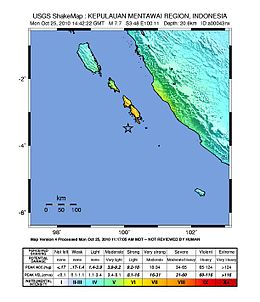
| UTC time | 2010-10-25 14:42:22 |
|---|---|
| ISC event | 15264887 |
| USGS-ANSS | ComCat |
| Local date | 25 October 2010 |
| Local time | 21:42:22 |
| Magnitude | 7.8 Mw |
| Depth | 12.8 miles (20.6 km) |
| Epicenter | 3°29′13″S 100°04′55″E / 3.487°S 100.082°E[1][2] |
| Fault | Sunda megathrust |
| Type | Thrust fault |
| Areas affected | Indonesia |
| Max. intensity | MMI V (Moderate)[1] |
| Casualties | 408 dead + 303 missing[3] |
The 2010 Mentawai earthquake occurred with a moment magnitude of 7.8[1] on 25 October off the western coast of Sumatra at 21:42 local time (14:42 UTC).[4] The earthquake occurred on the same fault that produced the 2004 Indian Ocean earthquake. It was widely felt across the provinces of Bengkulu and West Sumatra and resulted in a substantial localized tsunami that struck the Mentawai Islands.[5]
- ^ a b c Cite error: The named reference
USGS-mainquakewas invoked but never defined (see the help page). - ^ Cite error: The named reference
maps-googlewas invoked but never defined (see the help page). - ^ Cite error: The named reference
Jakarta Globe Indonesia Battleswas invoked but never defined (see the help page). - ^ "BBC News – Major earthquake strikes off Indonesia". BBC. 2010-10-25. Retrieved 2010-10-26.
- ^ "Tsunami Bulletin". Pacific Tsunami Warning Center. 2010-10-25. Archived from the original on 2011-02-23. Retrieved 2010-10-27.

