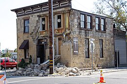
 Damage to the Sam Kee Laundry Building | |
| UTC time | 2014-08-24 10:20:44 |
|---|---|
| ISC event | 610572079 |
| USGS-ANSS | ComCat |
| Local date | August 24, 2014 |
| Local time | 03:20:44 PDT (UTC-7) |
| Magnitude | 6.0 Mw[1] |
| Depth | 7 mi (11 km)[1] |
| Epicenter | 38°13′N 122°19′W / 38.22°N 122.31°W[1] |
| Fault | West Napa Fault |
| Type | Strike-slip[1] |
| Areas affected | North Bay (San Francisco Bay Area) California, United States |
| Total damage | $362 million–$1 billion[2][3] |
| Max. intensity | MMI VIII (Severe)[1] |
| Peak acceleration | 0.61 g[4] |
| Casualties | 1 killed[5] about 200 injured[6] |
The 2014 South Napa earthquake occurred in the North San Francisco Bay Area on August 24 at 03:20:44 Pacific Daylight Time. At 6.0 on the moment magnitude scale and with a maximum Mercalli intensity of VIII (Severe), the event was the largest in the San Francisco Bay Area since the 1989 Loma Prieta earthquake. The epicenter of the earthquake was located to the south of Napa and to the northwest of American Canyon on the West Napa Fault.[7]
Total damage in the southern Napa Valley and Vallejo areas was in the range of $362 million to $1 billion, with one person killed and 200 injured. Other aspects of the event included an experimental earthquake warning system that alerted seismologists several seconds before the damaging shear waves arrived, temporary changes in springs and wells, and the potential for postseismic fault creep.
- ^ a b c d e Cite error: The named reference
usgswas invoked but never defined (see the help page). - ^ Cite error: The named reference
362 millionwas invoked but never defined (see the help page). - ^ Cite error: The named reference
latimeseconomicwas invoked but never defined (see the help page). - ^ Brocher, T. M.; Baltay, A. S.; Hardebeck, J. L.; Pollitz, F. F.; Murray, J. R.; Llenos, A. L.; Schwartz, D. P.; Blair, J. L.; Ponti, D. J.; Lienkaemper, J. J.; Langenheim, V. E.; Dawson, T. E.; Hudnut, K. W.; Shelly, D. R.; Dreger, D. S.; Boatwright, J.; Aagaard, B. T.; Wald, D. J.; Allen, R. M.; Barnhart, W. D.; Knudsen, K. L.; Brooks, B. A.; Scharer, K. M. (2015). "The Mw 6.0 24 August 2014 South Napa Earthquake". Seismological Research Letters. 86 (2A): 309–326. Bibcode:2015SeiRL..86..309B. doi:10.1785/0220150004.
- ^ Levs, Josh (September 11, 2014), Powerful California earthquake now blamed for one death, CNN
- ^ Cite error: The named reference
PD-NPBwas invoked but never defined (see the help page). - ^ Fimrite, Peter (August 27, 2014). "Boats, grapes and Poseidon at Napa quake's epicenter". San Francisco Chronicle. Retrieved September 2, 2017.
