| A1058 | |
|---|---|
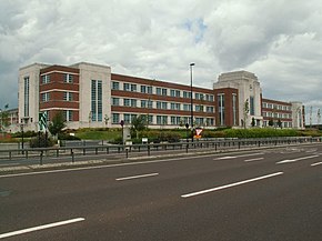
 W. D. and H. O. Wills Building on A1058 | |
| Route information | |
| Length | 7.4 mi (11.9 km) |
| Major junctions | |
| West end | Jesmond 54°58′58″N 1°36′16″W / 54.9828°N 1.6044°W |
| East end | Tynemouth 55°01′30″N 1°26′07″W / 55.0251°N 1.4354°W |
| Location | |
| Country | United Kingdom |
| Road network | |
The A1058, known locally as the Coast Road,[1][2] is a major road in Newcastle upon Tyne and the adjoining borough of North Tyneside in the North East. It runs from the Newcastle Central Motorway to the coast, terminating between Whitley Bay and Tynemouth. From west to east it connects Newcastle city centre with Jesmond, Heaton, Wallsend, Battle Hill, Howdon, Meadow Well, North Shields, Whitley Bay and Tynemouth. The road has existed since December 1924, when it was opened by then-transport minister Wilfrid Ashley.[3]
For five miles (8 kilometres) of its eight-mile (12.5 kilometre) route it is a full urban dual carriageway with grade separated interchanges and, for four of those miles, was 70-mile per hour national speed limit Now reduced to 50 miles per hour as of October 2023. However, it is not built to full UK standards for motorway-style roads, as it has too many entrances and exits and most of its sliproads have pedestrian crossings.
- ^ Goodwin, Nicole (24 January 2022). "'RIP Meat Loaf' graffiti appears on Heaton roundabout after rock legend's death". ChronicleLive. Retrieved 11 March 2022.
- ^ Graham, Hanna (2 April 2019). "The A19 under Silverlink Roundabout is open – but when will Coast Road speed limits end?". ChronicleLive. Retrieved 11 March 2022.
- ^ "Two Magnificent Roads". British Pathé. 15 December 1924. Retrieved 11 March 2022.
