| A22 | |
|---|---|
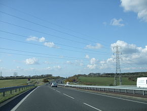
 A22 near Eastbourne in East Sussex. | |
| Route information | |
| Length | 48.3 mi[1] (77.7 km) |
| Major junctions | |
| South end | 50°47′06″N 0°16′26″E / 50.785°N 0.274°E |
| |
| North end | 51°20′15″N 0°07′00″W / 51.3375°N 0.1166°W |
| Location | |
| Country | United Kingdom |
| Counties | East Sussex, West Sussex, Surrey, Greater London |
| Primary destinations | Croydon East Grinstead |
| Road network | |
The A22 is one of the two-digit major roads in the south east of England. Radial, it carries traffic from London to the Eastbourne area of the East Sussex coast, in which town it ends.
- ^ "Eastbourne BN23 6PT, UK to Godstone, United Kingdom to Purley CR8 2HA, UK". Google Maps. Alphabet Inc. Retrieved 17 April 2023.

