| Site of Special Scientific Interest | |
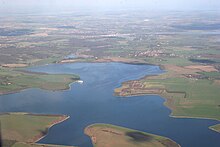
 View from south-west | |
| Location | Essex |
|---|---|
| Grid reference | TL970180 |
| Interest | Biological |
| Area | 700 ha (1,700 acres) |
| Notification | 1988 |
| Location map | Magic Map |
| Abberton Reservoir | |
|---|---|
| Coordinates | 51°49.2′N 00°51.6′E / 51.8200°N 0.8600°E |
| Lake type | Reservoir |
| Primary inflows | Pumped from River Stour and River Great Ouse |
| Managing agency | Essex and Suffolk Water |
| First flooded | 1939 |
| Surface area | 700 ha (1,700 acres) |
| Max. depth | 17 m (56 ft) |
| Water volume | 41,000 megalitres (9.0×10⁹ imp gal) |
| Designated | 24 July 1981 |
| Reference no. | 220[1] |
Abberton Reservoir is a pumped storage freshwater reservoir in eastern England near the Essex coast, with an area of 700 hectares (1,700 acres). Most of its water is pumped from the River Stour. It is the largest body of freshwater in Essex.
Constructed between 1935 and 1939, Abberton Reservoir is owned and managed by Essex and Suffolk Water, part of Northumbrian Water Group, and lies 6 km (3.7 mi) south-west of Colchester near the village of Layer de la Haye. In World War II, the reservoir was mined to deter invading seaplanes, and it was used by the RAF's No. 617 Squadron ("The Dam Busters") for practice runs for the bombing of the German dams in the Ruhr. A project to increase the capacity of Abberton Reservoir to 41,000 megalitres (9.0×10⁹ imp gal) by raising its bank height was completed in 2013, along with a new link to transfer water from Norfolk's River Ouse to the Stour.
The reservoir is important for its breeding cormorants, wintering and moulting waterfowl, and migrating birds. It is an internationally important wetland, designated as a Ramsar site, Site of Special Scientific Interest and Special Protection Area, and is listed in A Nature Conservation Review. A small part of the site is managed by the Essex Wildlife Trust.
- ^ "Abberton Reservoir". Ramsar Sites Information Service. Archived from the original on 30 May 2018. Retrieved 25 April 2018.

