Abbeyfeale
Mainistir na Féile | |
|---|---|
Town | |
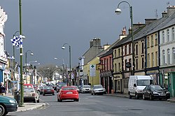
 Abbeyfeale Main Street | |
| Coordinates: 52°23′10″N 9°17′38″W / 52.386°N 9.294°W | |
| Country | Ireland |
| Province | Munster |
| County | Limerick |
| Local electoral area | Newcastle |
| Dáil constituency | Limerick County |
| EU Parliament | South |
| Elevation | 75 m (246 ft) |
| Population | |
| • Total | 2,206 |
| Time zone | UTC0 (WET) |
| • Summer (DST) | UTC+1 (IST) |
| Eircode routing key | V94 |
| Area code | +353(0)68 |
| Irish Grid Reference | R111268 |
| Website | abbeyfeale.ie |
Abbeyfeale (/ˈæbifeɪl/; Irish: Mainistir na Féile, meaning 'abbey of the Feale'[2]) is a historic market town in County Limerick, Ireland, near the border with County Kerry. The town is on the N21 road from Limerick to Tralee, some 21 kilometres (13 miles) south-west of Newcastle West and 16 kilometres (10 miles) south-east of Listowel and 38 kilometres (24 miles) north-east of Tralee. The town is in a civil parish of the same name.[2]
- ^ "Census 2022 Sapmap Area: Settlements Abbeyfeale". Census 2022. Central Statistics Office.
- ^ a b "Mainistir na Féile/Abbeyfeale". logainm.ie. Placenames Database of Ireland. Retrieved 4 December 2021.
