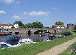
Abingdon Bridge | |
|---|---|
 Abingdon Bridge, looking downstream from the top of Nag's Head Island | |
| Coordinates | 51°40′07″N 1°16′46″W / 51.6686°N 1.2795°W |
| Carries | A415 road |
| Crosses | River Thames |
| Locale | Abingdon, Oxfordshire |
| Maintained by | Oxfordshire County Council |
| Heritage status | Grade II listed[1] |
| Characteristics | |
| Design | Arch bridge |
| Material | Stone |
| No. of spans | 6 |
| Piers in water | 5 |
| History | |
| Construction start | 1416 |
| Construction end | 1422, rebuilt 1927 |
| Location | |
 | |
Burford Bridge | |
|---|---|
 Burford Bridge at Abingdon from downstream | |
| Coordinates | 51°40′06″N 1°16′45″W / 51.668396°N 1.279113°W |
| Heritage status | Grade II listed[1] |
| Characteristics | |
| Design | Arch bridge |
| Material | Stone |
| Height | 13 feet 11 inches (4.24 m)[2] |
| No. of spans | 7 |
| Piers in water | 3 |
| History | |
| Construction end | 1453, rebuilt 1927 |
| Location | |
 | |
Abingdon Bridge crosses the River Thames at the town of Abingdon, Oxfordshire, England. It carries the A415 road from Abingdon to Dorchester, Oxfordshire, over the reach of the Thames between Culham Lock and Abingdon Lock.
The bridge is actually two bridges, linked by Nag's Head Island. Abingdon Bridge is the northern part towards the town which has six arches and crosses the backwater and mill stream. The southern part is technically called Burford Bridge and has one main arch and four minor arches at the river and two minor arches on the floodplain. This crosses the main navigation channel. Furthermore, to complete the Thames crossing, Culham Bridge crossing the Swift Ditch should also be considered as an extension.
- ^ a b Historic England (19 January 1951). "Abingdon Bridge Burford Bridge (1048926)". National Heritage List for England. Retrieved 27 October 2013.
- ^ "The River Thames – Bridge lists and statistics". Archived from the original on 9 May 2008. Retrieved 21 April 2008.