Abra | |
|---|---|
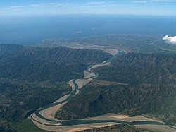
(from top: left to right) Bangued, Tayum Church, Abra Provincial Capitol, Bucay Casa Real, San Quintin and Abra River. | |
 Location in the Philippines | |
| Coordinates: 17°35′N 120°45′E / 17.58°N 120.75°E | |
| Region | Cordillera Administrative Region |
| Founded | March 10, 1917 |
| Capital and largest municipality | Bangued |
| Government | |
| • Governor | Dominic B. Valera (NUP/ASENSO) |
| • Vice Governor | Maria Jocelyn V. Bernos[a][1][b] (NUP/ASENSO) Russell Bragas (acting) |
| • Legislature | Abra Provincial Board |
| Area | |
• Total | 4,165.25 km2 (1,608.21 sq mi) |
| • Rank | 29th out of 81 |
| Highest elevation | 2,467 m (8,094 ft) |
| Population (2020 census)[5] | |
• Total | 250,985 |
| • Rank | 68th out of 81 |
| • Density | 60/km2 (160/sq mi) |
| • Rank | 80th out of 81 |
| Divisions | |
| • Independent cities | 0 |
| • Component cities | 0 |
| • Municipalities | |
| • Barangays | 303 |
| • Districts | Legislative districts of Abra |
| Time zone | UTC+8 (PHT) |
| IDD : area code | +63 (0)74 |
| ISO 3166 code | PH-ABR |
| Spoken languages | |
| Website | www |
Abra, officially the Province of Abra (Ilocano: Probinsia ti Abra; Tagalog: Lalawigan ng Abra), is a province in the Cordillera Administrative Region of the Philippines. Its capital is the municipality of Bangued, the most populous in the province. It is bordered by Ilocos Norte on the northwest, Apayao on the northeast, Kalinga on the mid-east, Mountain Province on the southeast, and Ilocos Sur on the southwest.
Cite error: There are <ref group=lower-alpha> tags or {{efn}} templates on this page, but the references will not show without a {{reflist|group=lower-alpha}} template or {{notelist}} template (see the help page).
- ^ "Court stops Malacañang's suspension of Abra vice governor". Rappler. September 6, 2024. Retrieved September 6, 2024.
- ^ Quitasol, Aldwin (September 30, 2024). "Abra vice governor suspension final, says OP". Retrieved September 30, 2024.
- ^ "Malacañang suspends Abra vice governor over COVID-19 hospital lockdown order". Rappler. August 23, 2024. Retrieved August 23, 2024.
- ^ "List of Provinces". PSGC Interactive. Makati, Philippines: National Statistical Coordination Board. Archived from the original on April 19, 2016. Retrieved May 14, 2014.
- ^ Census of Population (2020). "Cordillera Administrative Region (CAR)". Total Population by Province, City, Municipality and Barangay. Philippine Statistics Authority. Retrieved July 8, 2021.


