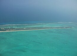
 Agatti Airport | |
Location of Agatti Atoll in Lakshadweep | |
| Geography | |
|---|---|
| Location | Arabian Sea |
| Coordinates | 10°30′N 73°00′E / 10.50°N 73°E |
| Type | Atoll |
| Archipelago | Lakshadweep |
| Adjacent to | Indian Ocean |
| Total islands | 2 |
| Major islands |
|
| Area | 3.226 km2 (1.246 sq mi)[1] |
| Length | 7.6 km (4.72 mi) |
| Width | 0.85 km (0.528 mi) |
| Coastline | 17 km (10.6 mi) |
| Highest elevation | 2 m (7 ft) |
| Administration | |
| Territory | Union territory of Lakshadweep |
| District | Lakshadweep |
| Island group | Laccadive Islands |
| Tehsils of India | Kavaratti |
| Subdivisions of India | Agatti Island |
| Largest settlement | Agatti (pop. 7500) |
| Demographics | |
| Population | 7700 (2014) |
| Pop. density | 2,386/km2 (6180/sq mi) |
| Ethnic groups | Malayali, Mahls |
| Additional information | |
| Time zone | |
| PIN | 682553 |
| Telephone code | 04894 |
| ISO code | IN-LD-06[2] |
| Official website | www |
| Literacy | 84.4% |
| Avg. summer temperature | 32.0 °C (89.6 °F) |
| Avg. winter temperature | 28.0 °C (82.4 °F) |
| Sex ratio | 1.059♂/♀ |
Agatti Island (Malayalam: [ɐɡɐt̪ːi]) is a 7.6 km long island, situated on a coral atoll called Agatti atoll in the Union Territory of Lakshadweep, India. It is 459 km (285 mi) west of the city of Kochi.
- ^ "Islandwise Area and Population - 2011 Census" (PDF). Government of Lakshadweep. Archived from the original (PDF) on 22 July 2016.
- ^ Registration Plate Numbers added to ISO Code

