Agew Awi
አገው አዊ | |
|---|---|
 | |
 | |
| Country | Ethiopia |
| Region | Amhara |
| Largest city | Injibara |
| Area | |
• Total | 9,148.43 km2 (3,532.23 sq mi) |
| Population (2017 est.) | |
• Total | 1,077,144 |
| • Density | 120/km2 (300/sq mi) |

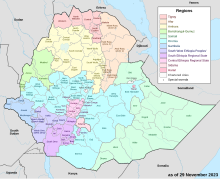
Agew Awi (Amharic: አገው አዊ) is a zone in the Amhara Region of Ethiopia. It is named for the Awi sub-group of the Agaw people, some of whom live in this Zone. Agew Awi Zone is bordered on the west by Benishangul-Gumuz Region, on the north by North Gondar Zone and on the east by West Gojjam. The administrative centre of Agew Awi is Injibara; other towns include Chagni, Agew Gimjabet, Tilili, Adis Kidame, Azena, Zigem, Jawi and Dangila.
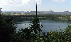
Topographically speaking, Agaw Awi is relatively flat and fertile, whose elevations vary from 1,800 to 3,100 m above sea level, with an average altitude of about 2,300 m. The Zone is crossed by about nine permanent rivers which drain into the Abay (or Blue Nile); other water features include two crater lakes, Zengena and Tirba, and Zimbiri marsh which is located 5 km south-west of Addis Kidam. Local forests include Dukma and Apini, which are located on either side of the town of Kidamaja, Zengena forest around Lake Zengena and Goobil forest which is on a dome-shaped hill next to Kessa. The Agaw have traditionally practised a land-management system which is well adapted to the local ecology, which enables them to sustain the fertility of the soil and minimize erosion; this area is recognized as one of the most productive in the Amhara Region.[2]
- ^ Geohive: Ethiopia Archived 2012-08-05 at the Wayback Machine
- ^ "Important Bird Area factsheet: Awi Zone, Ethiopia", BirdLife International website (accessed 1 September 2009)
