Agoura Hills, California | |
|---|---|
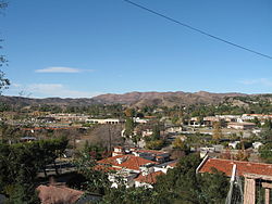
 View of Agoura Hills looking from southern edge of the Historic Quarter in December 2006 | |
| Motto: "The Gateway to the Santa Monica Mountains"[1] | |
 Location of Agoura Hills in Los Angeles County | |
Location of Agoura Hills in the Los Angeles metropolitan area | |
| Coordinates: 34°9′12″N 118°45′42″W / 34.15333°N 118.76167°W | |
| Country | United States |
| State | California |
| County | Los Angeles |
| Region | Conejo Valley |
| Settled (by the Spanish) | 1700s |
| Incorporated | December 8, 1982[2] |
| Named for | Don Pierre Agoure |
| Government | |
| • Type | City Council/City Manager[3] |
| • Mayor | Illece Buckley Weber |
| • Mayor pro tem | Penny Sylvester |
| • City Council |
|
| • City Manager | Nathan Hamburger |
| Area | |
| • Total | 7.82 sq mi (20.25 km2) |
| • Land | 7.80 sq mi (20.19 km2) |
| • Water | 0.02 sq mi (0.06 km2) 0.37% |
| Elevation | 922 ft (281 m) |
| Population (2020) | |
| • Total | 20,299 |
| • Density | 2,603.77/sq mi (1,005.37/km2) |
| Time zone | UTC−8 (Pacific Time Zone) |
| • Summer (DST) | UTC−7 (PDT) |
| ZIP Codes | 91301, 91376–91377[6] |
| Area code | 747/818[7] |
| FIPS code | 06-00394[8] |
| GNIS feature IDs | 1733436, 2409666 |
| Website | www |
Agoura Hills (/əˈɡɔːrə ˈhɪlz/ ) is a city situated in the Santa Monica Mountains[9] region of Los Angeles County, California, United States. With a population of 20,330 as of the 2010 census,[8] which decreased to 20,299 in 2020.[10] Agoura Hills lies in the eastern Conejo Valley, nestled between the Simi Hills and the Santa Monica Mountains. Located 35 miles (56 km) northwest of Downtown Los Angeles and less than 10 miles (16 km) west of the Los Angeles city limits at Woodland Hills, Agoura Hills is bordered by Bell Canyon and Ventura County. Neighboring communities include Calabasas, Oak Park, and Westlake Village, while the unincorporated area of Agoura sits adjacent.
- ^ "City of Agoura Hills, California". City of Agoura Hills, California. Archived from the original on July 11, 2020. Retrieved August 11, 2012.
- ^ "California Cities by Incorporation Date". California Association of Local Agency Formation Commissions. Archived from the original (Word) on November 3, 2014. Retrieved August 25, 2014.
- ^ "Council Members". City of Agoura Hills, CA. Archived from the original on September 23, 2015. Retrieved December 16, 2014.
- ^ "2020 U.S. Gazetteer Files". United States Census Bureau. Retrieved October 30, 2021.
- ^ "Agoura". Geographic Names Information System. United States Geological Survey, United States Department of the Interior. Retrieved October 16, 2014.
- ^ "USPS – ZIP Code Lookup – Find a ZIP+ 4 Code By City Results". Retrieved January 17, 2007.
- ^ "Number Administration System – NPA and City/Town Search Results". Archived from the original on September 26, 2007. Retrieved January 18, 2007.
- ^ a b "Agoura Hills (city) QuickFacts". United States Census Bureau. Archived from the original on March 29, 2015. Retrieved March 26, 2015.
- ^ "Santa Monica Mountains". Mapping L.A. Retrieved May 20, 2021.
- ^ "QuickFacts: Agoura Hills, CA". Retrieved December 21, 2021.


