Aguas Buenas
Municipio Autónomo de Aguas Buenas | |
|---|---|
Town and Municipality | |
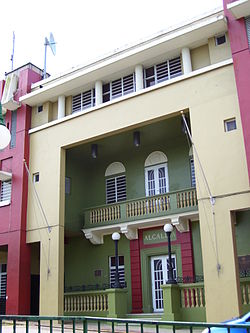
 Town Hall of Aguas Buenas | |
| Nicknames: La Ciudad de las Aguas Claras, Los Mulos, El Oasis de Puerto Rico, Los Ñocos | |
| Anthem: "Yo Soy Aguas Buenas" | |
 Map of Puerto Rico highlighting Aguas Buenas Municipality | |
| Coordinates: 18°15′25″N 66°06′11″W / 18.25694°N 66.10306°W | |
| Sovereign state | |
| Commonwealth | |
| Settled | 1798 |
| Founded | May 25, 1838 |
| Barrios | |
| Government | |
| • Mayor | Karina Nieves Serrano (PNP) |
| • Senatorial dist. | 1 – San Juan |
| • Representative dist. | 5 |
| Area | |
| • Total | 30.12 sq mi (78.01 km2) |
| • Land | 30.12 sq mi (78.00 km2) |
| • Water | 0.004 sq mi (.01 km2) |
| Population (2020)[1] | |
| • Total | 24,223 |
| • Rank | 49th in Puerto Rico |
| • Density | 800/sq mi (310/km2) |
| Demonym | Aguasbonenses |
| Time zone | UTC−4 (AST) |
| ZIP Code | 00703 |
| Area code | 787/939 |
| Major routes | |
| Website | http://legislaturaaguasbuenas.com/ |
Aguas Buenas, (Spanish pronunciation: [ˈaɣwas ˈβwenas], local pronunciation: [awaʔ ˈβwenaʔ]), popularly known as "La Ciudad de las Aguas Claras" or "The City of Clear Waters", is a town and municipality of Puerto Rico located in the Central Mountain Range, north of Cidra, south of Bayamón, Guaynabo and San Juan; east of Comerio; and north-west of Caguas. Aguas Buenas is spread over 9 barrios and Aguas Buenas Pueblo (the downtown area and the administrative center of the city). It is part of the San Juan-Caguas-Guaynabo Metropolitan Statistical Area.
- ^ Bureau, US Census. "PUERTO RICO: 2020 Census". The United States Census Bureau. Retrieved August 25, 2021.
{{cite web}}:|last=has generic name (help)

