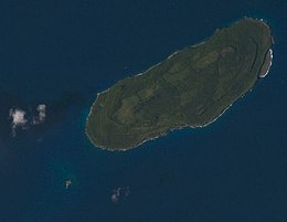
 Satellite view, with Naftan Rock visible to the southwest | |
 | |
| Geography | |
|---|---|
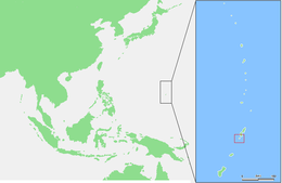
| Location | Pacific Ocean |
| Coordinates | 14°51′13″N 145°33′34″E / 14.85361°N 145.55944°E |
| Archipelago | Northern Mariana Islands |
| Area | 7.01 km2 (2.71 sq mi)[1] |
| Length | 4.7 km (2.92 mi) |
| Width | 1.8 km (1.12 mi) |
| Highest elevation | 157 m (515 ft) |
| Administration | |
United States | |
| Commonwealth | Northern Mariana Islands |
| Demographics | |
| Population | 25 (2022) |
Aguijan (/æɡɪˈjɑn/; Spanish: Aguiján [aɡiˈxan]; also Aguiguan and Aguihan, based on the Spanish rendition of the native name) is a small bean-shaped uninhabited coralline island in the Northern Mariana Islands chain in the Pacific Ocean. It is situated 8 kilometers (5.0 mi) south-west of Tinian, from which it is separated by the Tinian Channel. Aguijan and neighboring Tinian Island together form Tinian Municipality, one of the four main political divisions that comprise the Northern Marianas. The island is inhabited by wild goats and the last known habitat of a rare Pacific bat, as well as many species of birds. During WW2 a Japanese garrison was on the island, which surrendered at the end of the War without a battle. Access to the island is inhibited by the lack of a natural harbor.
- ^ "6 AGUIJAN" (PDF). National Oceanic and Atmospheric Administration. p. 1. Archived (PDF) from the original on 15 November 2020. Retrieved 15 November 2020.