Aguila, Arizona | |
|---|---|
 Aguila in 2012, looking west on U.S. Route 60 | |
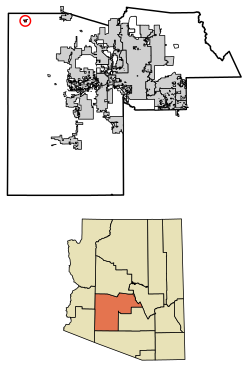
 Location in Maricopa County, Arizona | |
| Coordinates: 33°56′15″N 113°09′59″W / 33.93750°N 113.16639°W | |
| Country | United States |
| State | Arizona |
| County | Maricopa |
| Area | |
| • Total | 1.63 sq mi (4.22 km2) |
| • Land | 1.63 sq mi (4.22 km2) |
| • Water | 0.00 sq mi (0.00 km2) |
| Elevation | 2,175 ft (663 m) |
| Population | |
| • Total | 565 |
| • Density | 346.41/sq mi (133.76/km2) |
| Time zone | UTC−7 (Mountain (MST)) |
| ZIP Code | 85320 |
| Area code | 928 |
| FIPS code | 04-00730 |
| GNIS feature ID | 2582720[2] |
Aguila is an unincorporated community and census-designated place (CDP) in Maricopa County, Arizona, United States. It is located on U.S. Route 60, 25 miles (40 km) west of Wickenburg and 22 miles (35 km) northeast of Wenden. Major economic activities include cantaloupe farming and formerly included mining. It uses the same street numbering system as Phoenix. As of the 2020 census, the population of Aguila was 565,[3] down from 798 in 2010.
- ^ "2021 U.S. Gazetteer Files: Arizona". United States Census Bureau. Retrieved May 13, 2022.
- ^ a b U.S. Geological Survey Geographic Names Information System: Aguila, Arizona
- ^ a b "Aguila CDP, Arizona: 2020 DEC Redistricting Data (PL 94-171)". U.S. Census Bureau. Retrieved May 13, 2022.

