| Ahuriri Conservation Park | |
|---|---|
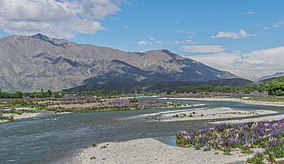
 Ahuriri Valley, as viewed from Omarama | |
| Location | Canterbury Region, New Zealand |
| Nearest city | Christchurch |
| Coordinates | 44°20′S 169°40′E / 44.333°S 169.667°E |
| Area | 49 hectares (120 acres) |
| Established | 2004 |
| Governing body | Department of Conservation |
Ahuriri Conservation Park is a protected area of 49,000 hectares including tussock grasslands, forest, and river habitat, located in Canterbury, South Island, New Zealand, and centred around the headwaters of the Ahuriri River.[1][2]
The park includes trails and huts.[3][4][5] The mountains, forests, tussock lands and river valleys are used for tramping, fishing kayaking, horse riding and hunting.[6]
Both the park and neighbouring Ben Avon Station are located near the Aoraki Mackenzie International Dark Sky Reserve, a dark-sky reserve, and are used for astronomy.[7]
The town is serviced by the tourist town of Omarama.[8][9]
- ^ "Speech: Opening of Ahuriri Conservation Park". The Beehive. New Zealand: Government of New Zealand. Retrieved 2019-09-15.
- ^ "Ahuriri hunting block". National Library of New Zealand. Retrieved 2019-09-15.
- ^ "Ahuriri Conservation Park". www.doc.govt.nz. Government of New Zealand.
- ^ "Ahuriri Conservation Park" (PDF). New Zealand: Government of New Zealand.
- ^ "Ahuriri Conservation Park: Discover Omarama". Retrieved 2019-09-15.
- ^ Thornber, Lorna (28 July 2021). "NZ's top winter towns: Where to go in August for a last-minute escape". stuff.co.nz. Stuff Travel.
- ^ Wallace, Sue (1 October 2020). "Dark skies and designer lodges in the Ahuriri Valley". New Zealand Media and Entertainment. New Zealand Herald.
- ^ Waterworth, Kerrie (25 November 2020). "A quieter time for Omarama this year". Allied Press. Otago Daily Times.
- ^ Editorial (24 May 2018). "Omarama at a crossroads". Allied Press. Otago Daily Times.
