| Akhuryan | |
|---|---|
 | |
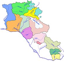
 Akhuryan river and its basin (blue) within Armenia | |
| Native name | |
| Location | |
| Country | Armenia and Turkey |
| Physical characteristics | |
| Source | Lake Arpi |
| • location | Shirak, Armenia |
| • coordinates | 41°04′05″N 43°39′14″E / 41.068°N 43.654°E |
| • elevation | 2,023 m (6,637 ft) |
| Mouth | Aras |
• location | Near Bagaran, Armenia |
• coordinates | 40°07′53″N 43°38′54″E / 40.1315°N 43.6484°E |
• elevation | 953 m (3,127 ft) |
| Length | 186 km (116 mi) |
| Basin size | 9,670 km2 (3,730 sq mi) |
| Basin features | |
| Progression | Aras→ Kura→ Caspian Sea |
The Akhuryan (Armenian: Ախուրյան, romanized: Akhuryan)[a] or Arpachay (Turkish: Arpaçay)[2][3] is a river in the South Caucasus. It originates in Armenia and flows from Lake Arpi, along the closed border with Turkey, forming part of the geographic border between the two states, until it flows into the Aras as a left tributary near Bagaran. The Akhuryan is 186 km (116 mi) long, and has a 9,670 km2 (3,730 sq mi) drainage basin.[4]
Gyumri, the second largest city of Armenia, is located on the east bank of the river.
- ^ "Arpachaĭ" Арпачай. Brockhaus and Efron Encyclopedic Dictionary (in Russian). Vol. II. 1890. p. 160.
- ^ Karimov, Mahmud (2007). National Encyclopedia of Azerbaijan (PDF). Baku: Azerbaijan National Academy of Sciences. ISBN 978-9952-441-01-7.
- ^ "Arpaçay Nehri". 2012 Yılı Kars İli ÇED Raporu (PDF). 2012. Archived from the original (PDF) on January 8, 2015. Retrieved May 5, 2019.
- ^ Ахурян, Great Soviet Encyclopedia
Cite error: There are <ref group=lower-alpha> tags or {{efn}} templates on this page, but the references will not show without a {{reflist|group=lower-alpha}} template or {{notelist}} template (see the help page).

