Akitakata
安芸高田市 | |
|---|---|
 Akitakata city hall | |
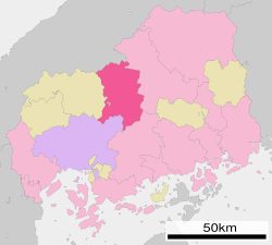
 Location of Akitakata in Hiroshima Prefecture | |
 | |
| Coordinates: 34°39′47″N 132°42′23″E / 34.66306°N 132.70639°E | |
| Country | Japan |
| Region | Chūgoku (San'yō) |
| Prefecture | Hiroshima |
| Government | |
| • Mayor | Etsushi Fujimoto (since July 2024) |
| Area | |
| • Total | 537.75 km2 (207.63 sq mi) |
| Population (May 1, 2023) | |
| • Total | 26,810 |
| • Density | 50/km2 (130/sq mi) |
| Time zone | UTC+09:00 (JST) |
| City hall address | Yoshidachō, Yoshida 791, Akitakata-shi, Hiroshima-ken 731-0592 |
| Website | Official website |
| Symbols | |
| Flower | Hydrangea |
| Tree | Cherry blossom |


Akitakata (安芸高田市, Akitakata-shi) is a city located in north-central Hiroshima Prefecture, Japan. As of 1 May 2023[update], the city had an estimated population of 26,810 in 13,319 households and a population density of 50 persons per km².[1] The total area of the city is 537.75 square kilometres (207.63 sq mi).The city lays claim to be the birthplace and hometown of Mōri Motonari, the Sengoku period daimyō of the 16th century.
- ^ "Akitakata city official statistics" (in Japanese). Japan.


