This article needs additional citations for verification. (May 2021) |
Aksaray | |
|---|---|
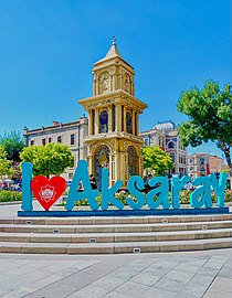
 Clock Tower in Aksaray Square | |
| Coordinates: 38°22′27″N 34°01′44″E / 38.37417°N 34.02889°E | |
| Country | Turkey |
| Province | Aksaray |
| District | Aksaray |
| Government | |
| • Mayor | Evren Dinçer[1] (AKP) |
| Elevation | 980 m (3,220 ft) |
| Population (2021)[2] | 247,147 |
| Time zone | UTC+3 (TRT) |
| Postal code | 68100 |
| Area code | 0382 |
| Website | www |
Aksaray (pronounced [ˈaksaɾaj]) is a city in the Central Anatolia region of Turkey. It is the seat of Aksaray Province and Aksaray District.[3] Its population is 247,147 (2021).[2] In 2021 the province had an estimated population of 429,069 distributed over about 7,659 km2 (2,957 sq mi).[2][4] The average elevation is 980 m (3,215 ft), with the highest point being Mt. Hasan (Turkish: Hasan Dağı) at 3,268 m (10,722 ft).
The city of Aksaray has a long history and was an important stopover point on the Silk Road that transited Anatolia for centuries. It is a mid-sized city with the Melendiz river running through it and several monuments dating back to the pre-Ottoman era as well as some impressive examples of government buildings from the early Turkish Republic that are gathered around the main square.
The nearest airport is Kapadokya Nevşehir Airport (NAV) which is 62.1 km away from the city.
- ^ "Aksaray Election Results – March 31 2019 Aksaray Local Election results". Yeni Şafak. 26 November 2019. Retrieved 2019-11-26.
- ^ a b c "Address-based population registration system (ADNKS) results dated 31 December 2021" (XLS) (in Turkish). TÜİK. Retrieved 12 January 2023.
- ^ İl Belediyesi, Turkey Civil Administration Departments Inventory. Retrieved 12 January 2023.
- ^ "İl ve İlçe Yüz ölçümleri". General Directorate of Mapping. Retrieved 12 January 2023.

