| Aksu Saryjaz | |
|---|---|
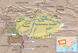
 Aksu River shown within the Tarim basin | |
 | |
| Etymology | Ak Su (white/clear water, Turkish) |
| Native name | |
| Location | |
| Country | Kyrgyzstan, China |
| Physical characteristics | |
| Source | Semyonov's glacier, Kyrgyzstan |
| Mouth | Tarim |
• coordinates | 40°27′32″N 80°51′58″E / 40.459°N 80.866°E |
| Length | 282 km (175 mi) |
| Basin size | 31,982 km2 (12,348 sq mi) |
| Discharge | |
| • location | Aksu, Xinjiang |
| • average | 249 m3/s (8,800 cu ft/s) |
| Basin features | |
| Progression | Tarim→ Taitema Lake |
| Tributaries | |
| • left | Engilchek, Kayyngdy |
| • right | Köölü, Üchköl, Ak-Shyyrak, Toshkan |
The Aksu River (Uyghur: ئاقسۇ دەرياسى, romanized: Aqsu deryasi; simplified Chinese: 阿克苏河; traditional Chinese: 阿克蘇河; pinyin: Ākèsū Hé; means "white/clear water" in Uyghur and Kyrgyz languages) is a transboundary river in the Xinjiang province in China and Ak-Suu District of Issyk-Kul Province of Kyrgyzstan. Its upper section in Kyrgyzstan is known as the Saryjaz River or Sarydzhaz River (Chinese: 萨雷扎兹河, Kyrgyz: Сарыжаз). The middle section, between the Kyrgyz-Chinese border and the confluence with the Toshkan, is called Kumarik River (Chinese: 库玛拉克河, Kyrgyz: Сарыжаз).[1] The total length of the river is 282 kilometres (175 mi), of which 197 kilometres (122 mi) are in Kyrgyzstan. It has a drainage basin of 12,900 square kilometres (5,000 sq mi) in Kyrgyzstan.[2][3] The Aksu is the only one of the Tarim's source rivers to run throughout the year.
- ^ Wortmann, M.; et al. (2014). "Assessing the influence of the Merzbacher Lake outburst floods on discharge using the hydrological model SWIM in the Aksu headwaters, Kyrgyzstan/NW China". Hydrological Processes. 28 (26): 6337–6350. Bibcode:2014HyPr...28.6337W. doi:10.1002/hyp.10118. S2CID 2046602.
- ^ "Сарыжаз" [Saryjaz] (PDF). Кыргызстандын Географиясы [Geography of Kyrgyzstan] (in Kyrgyz). Bishkek. 2004. pp. 203–204.
{{cite encyclopedia}}: CS1 maint: location missing publisher (link) - ^ Иссык-Куль. Нарын. Энциклопедия. [Issyk-Kul. Naryn.Encyclopedia.] (in Russian). Frunze: Chief Editorial Board of Kyrgyz Soviet Encyclopedia. 1991. p. 512. ISBN 5-89750-009-6.