Alamo Square | |
|---|---|
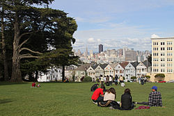
 Looking across Alamo Square Park towards the famous "Painted Ladies" and city skyline | |
| Coordinates: 37°46′35″N 122°26′05″W / 37.776384°N 122.434709°W | |
| Country | United States |
| State | California |
| City and county | San Francisco |
| Government | |
| • Supervisor | Dean Preston |
| • Assemblymember | Matt Haney (D)[1] |
| • State senator | Scott Wiener (D)[1] |
| • U. S. rep. | Nancy Pelosi (D)[2] |
| Area | |
| • Total | 0.463 sq mi (1.20 km2) |
| • Land | 0.463 sq mi (1.20 km2) |
| Population (2008)[3] | |
| • Total | 5,617 |
| • Density | 31,059/sq mi (11,992/km2) |
| Time zone | UTC-8 (Pacific) |
| • Summer (DST) | UTC-7 (PDT) |
| ZIP codes | 94115, 94117 |
| Area codes | 415/628 |
| [3] | |
Alamo Square is a residential neighborhood in San Francisco, California with a park of the same name. Located in the Western Addition, its boundaries are Buchanan Street on the east, Turk Street on the north, Baker Street on the west, and Page Street Street on the south.
Alamo Square Park, the neighborhood's focal point and namesake, consists of four city blocks at the top of a hill overlooking much of downtown San Francisco, with a number of large and architecturally distinctive mansions along the perimeter, including the "Painted Ladies", a well-known postcard motif. The park is bordered by Hayes Street to the south, Steiner Street to the east, Fulton Street to the north, and Scott Street to the west. Named after the lone cottonwood tree ("álamo" in Spanish), Alamo Hill, was a watering hole on the horseback trail from Mission Dolores to the Presidio in the 1800s. In 1856, Mayor James Van Ness created a 12.7 acres (5.1 ha) park surrounding the watering hole, creating "Alamo Square".[4]
- ^ a b "Statewide Database". UC Regents. Archived from the original on February 1, 2015. Retrieved December 9, 2014.
- ^ "California's 11th Congressional District - Representatives & District Map". Civic Impulse, LLC.
- ^ a b c "Western Addition neighborhood in San Francisco, California, 94102, 94109, 94115, 94117 detailed profile". City-Data. Retrieved January 25, 2011.
- ^ "Alamo Square". San Francisco Parks Alliance. May 10, 2012. Retrieved February 29, 2016.


