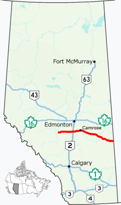
Highway 13 highlighted in red | ||||
| Route information | ||||
| Maintained by Alberta Transportation, the City of Wetaskiwin, and the City of Camrose | ||||
| Length | 366.0 km[1] (227.4 mi) | |||
| Major junctions | ||||
| West end | Range Road 74 near Alder Flats | |||
| ||||
| East end | ||||
| Location | ||||
| Country | Canada | |||
| Province | Alberta | |||
| Specialized and rural municipalities | Wetaskiwin No. 10 County, Camrose County, Flagstaff County, Provost No. 52 M.D. | |||
| Major cities | Wetaskiwin, Camrose | |||
| Towns | Daysland, Killam, Sedgewick, Hardisty, Provost | |||
| Villages | Bittern Lake, Bawlf, Lougheed, Amisk, Hughenden | |||
| Highway system | ||||
|
| ||||
| ||||
Highway 13 is an east–west highway through central Alberta. It runs from Alder Flats, 7 km (4 mi) west of Highway 22, to the Alberta-Saskatchewan border, where it becomes Saskatchewan Highway 14.[2] Highway 13 is about 366 kilometres (227 mi) long.[1] East of the City of Wetaskiwin, it generally parallels a Canadian Pacific Kansas City rail line.
- ^ a b Cite error: The named reference
overmapwas invoked but never defined (see the help page). - ^ "2015 Provincial Highways 1 - 216 Series Progress Chart" (PDF). Alberta Transportation. March 2015. Retrieved 2016-03-23.

