This article needs additional citations for verification. (July 2008) |
| Albrighton | |
|---|---|
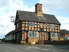
 The Shrewsbury Arms | |
Location within Shropshire | |
| Population | 4,326 (2011)[1] |
| OS grid reference | SJ812041 |
| Civil parish |
|
| Unitary authority | |
| Ceremonial county | |
| Region | |
| Country | England |
| Sovereign state | United Kingdom |
| Post town | Wolverhampton |
| Postcode district | WV7 |
| Dialling code | 01902 |
| Police | West Mercia |
| Fire | Shropshire |
| Ambulance | West Midlands |
| UK Parliament | |
Albrighton is a large village and civil parish in Shropshire, England, 8 miles (13 km) northwest of Wolverhampton and 11 miles (18 km) northeast of Bridgnorth.
The village has a railway station on the Shrewsbury to Wolverhampton Line,[2] and is near to RAF Cosford and the M54 motorway. It is the most easterly settlement in Shropshire. Immediately to the north is the hamlet and parish of Donington, which is separated from Albrighton by Humphreston Brook.[3]
- ^ "Civil Parish population 2011". Archived from the original on 4 March 2016. Retrieved 20 November 2015.
- ^ "Albrighton, Shropshire". Vision of Britain. Retrieved 12 July 2016.
- ^ Brew, Alec (1996). Albrighton & Shifnal. Stroud: Chalford. p. 28. ISBN 0-7524-0384-2.
