Alderney Airport | |||||||||||||||||||
|---|---|---|---|---|---|---|---|---|---|---|---|---|---|---|---|---|---|---|---|
 | |||||||||||||||||||
| Summary | |||||||||||||||||||
| Airport type | Public | ||||||||||||||||||
| Operator | States of Guernsey | ||||||||||||||||||
| Serves | Alderney | ||||||||||||||||||
| Location | St Anne | ||||||||||||||||||
| Elevation AMSL | 290 ft / 88 m | ||||||||||||||||||
| Coordinates | 49°42′24″N 002°12′52″W / 49.70667°N 2.21444°W | ||||||||||||||||||
| Website | alderney | ||||||||||||||||||
| Map | |||||||||||||||||||
 | |||||||||||||||||||
| Runways | |||||||||||||||||||
| |||||||||||||||||||
| Statistics (2022) | |||||||||||||||||||
| |||||||||||||||||||
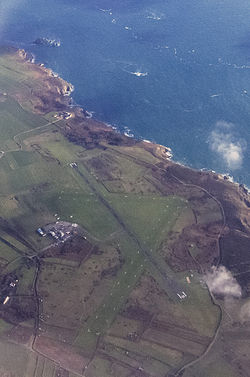
Alderney Airport (IATA: ACI, ICAO: EGJA) is the only airport on the island of Alderney, Guernsey. Built in 1935, Alderney Airport was the first airport in the Channel Islands. Located on the Blaye (1 NM (1.9 km; 1.2 mi) southwest of St Anne), it is the closest Channel Island airport to the south coast of England and the coast of France. Its facilities include a hangar, the Airport Fire Station, and avgas refuelling.
Alderney Airport is the base and on-record hub of Air Alderney, an airline that, as of 2022, has had problems commencing flights since 2017.
- ^ "Alderney - EGJA". Archived from the original on 12 March 2012. Retrieved 9 December 2008.
- ^ "UK airport data 2020: Tables 3, 9 and 13.pdf". UK Civil Aviation Authority. Retrieved 23 March 2023.

