| Aldington | |
|---|---|
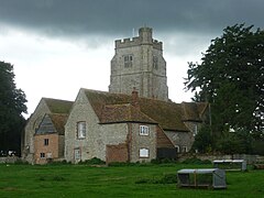
 St Martin’s Church, Aldington | |
Location within Kent | |
| Area | 18.23 km2 (7.04 sq mi) |
| Population | 1,573 (Civil Parish 2021)[1] |
| • Density | 86/km2 (220/sq mi) |
| OS grid reference | TR063365 |
| Civil parish |
|
| District | |
| Shire county | |
| Region | |
| Country | England |
| Sovereign state | United Kingdom |
| Post town | Ashford |
| Postcode district | TN25 |
| Dialling code | 01233 |
| Police | Kent |
| Fire | Kent |
| Ambulance | South East Coast |
| UK Parliament | |
Aldington is a village and civil parish in the Ashford District of Kent, England. The village centre is eight miles (12 km) south-east of the town of Ashford. As with the village centre, set on a steep escarpment above agricultural Romney Marsh and the upper Stour is Aldington Knoll, which was used as a Roman burial barrow and later beacon, it has a panorama towards the English Channel and of low land such as Dungeness. At the 2021 Census the population included Bonnington.
