Alexandra
Manuherikia or Areketanara (Māori) | |
|---|---|
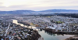
 Skyline of Alexandra in May 2022 | |
 | |
| Coordinates: 45°14′57″S 169°22′47″E / 45.24917°S 169.37972°E | |
| Country | New Zealand |
| Region | Otago |
| Territorial authority | Central Otago District |
| Ward | Vincent Ward |
| Community | Vincent Community |
| Electorates |
|
| Government | |
| • Territorial authority | Central Otago District Council |
| • Regional council | Otago Regional Council |
| • Mayor of Central Otago | Tamah Alley |
| • Southland MP | Joseph Mooney |
| • Te Tai Tonga MP | Tākuta Ferris |
| Area | |
• Total | 9.76 km2 (3.77 sq mi) |
| Elevation | 150 m (490 ft) |
| Population (June 2024)[3] | |
• Total | 6,150 |
| • Density | 630/km2 (1,600/sq mi) |
| Postcode | 9320 |
| Local iwi | Ngāi Tahu |
| Website | www |
Alexandra (Māori: Manuherikia[4][5] or Areketanara[6]) is a town in the Central Otago district of the South Island of New Zealand. It is on the banks of the Clutha River (at the confluence of the Manuherikia River), on State Highway 8, 188 kilometres (117 mi) by road from Dunedin and 33 kilometres (21 mi) south of Cromwell. The nearest towns to Alexandra via state highway 8 are Clyde seven kilometres to the northwest and Roxburgh forty kilometres to the south. State highway 85 also connects Alexandra to Omakau, Lauder, Oturehua, Ranfurly and on to Palmerston on the East Otago coast.
The town of Alexandra is home to 6,150 people as of June 2024.[3]
- ^ Cite error: The named reference
Areawas invoked but never defined (see the help page). - ^ "Worldwide Elevation Finder".
- ^ a b "Aotearoa Data Explorer". Statistics New Zealand. Retrieved 26 October 2024.
- ^ The Cyclopedia of New Zealand: Alexandra
- ^ Teara 1966: Alexandra
- ^ "Place Names of New Zealand – Ingoa Wāhi o Aotearoa". Native Council. Retrieved 20 February 2018.