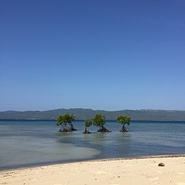
 The coast of Alibijaban facing Bondoc Peninsula | |
 | |
| Geography | |
|---|---|
| Location | 3.6 kilometers (2.2 mi) off San Andres, Quezon |
| Coordinates | 13°21′11″N 122°43′7″E / 13.35306°N 122.71861°E |
| Adjacent to | Ragay Gulf |
| Administration | |
| Region | Calabarzon |
| Province | Quezon |
| Municipality | San Andres |
Alibijaban is a small island located off the southeastern coast of Bondoc Peninsula in the island of Luzon. It belongs administratively to the municipality of San Andres, Quezon province, and is coterminous with the barangay of the same name. With a population of 1,738 inhabitants in 2020, it is the smallest of seven barangays in San Andres.[1]
The island is known for its pristine mangrove forest and coral reefs. It is also visited for its white sandy beaches and rich bird life.[2] Its mangrove forest which covers approximately 140 hectares (350 acres) of the island's central and northern portions is protected under the National Integrated Protected Areas System as a wilderness area called the Alibijaban Island Wilderness Area.[3] 225 hectares (560 acres) of waters surrounding it have also been declared a marine protected area known as the Alibijaban Fish Sanctuary.[4]
- ^ "Highlights of the Philippine Population 2015 Census of Population". 2015 Census of Population and Housing. Philippine Statistics Office. Retrieved 27 May 2016.
- ^ "Alibijaban Island Wilderness Area". Department of Environment and Natural Resources. Archived from the original on 3 February 2016. Retrieved 11 November 2015.
- ^ "Proclamation No. 2151, s. 1981". Official Gazette of the Republic of the Philippines. Retrieved 11 November 2015.
- ^ Atlas of Philippine Coral Reefs. Goodwill Trading Co., Inc. 2002. ISBN 9789711202507. Retrieved 11 November 2015.
