| Alloa | |
|---|---|
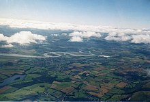
 Alloa from Clackmannan Tower with Ben Ledi and Wallace Monument in the distance | |
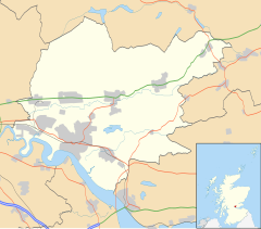
Location within Clackmannanshire | |
| Area | 3.52 sq mi (9.1 km2) |
| Population | 14,440 (2022)[5] |
| • Density | 4,102/sq mi (1,584/km2) |
| OS grid reference | NS900920 |
| Council area | |
| Lieutenancy area | |
| Country | Scotland |
| Sovereign state | United Kingdom |
| Post town | ALLOA |
| Postcode district | FK10 |
| Dialling code | 01259 |
| Police | Scotland |
| Fire | Scottish |
| Ambulance | Scottish |
| UK Parliament | |
| Scottish Parliament | |
Alloa (Received Pronunciation /ˈæloʊə/; Scottish pronunciation /ˈaloʊa/; Scottish Gaelic: Alamhagh, possibly meaning "rock plain"[6]) is a town in Clackmannanshire in the Central Lowlands of Scotland. It is on the north bank of the Forth at the spot where some say it ceases to be the River Forth and becomes the Firth of Forth.[7] Alloa is south of the Ochil Hills on the western Fife peninsula, 6.0 miles (9.7 km) east of Stirling and 13.0 miles (20.9 km) west of Dunfermline; by water Alloa is 25 miles (40 km) from Granton.[8]
The town, formerly a burgh of barony, is the administrative centre of Clackmannanshire Council. Historically, the economy relied heavily on trade between Glasgow and mainland Europe through its port.[9] This became increasingly uncompetitive and the port stopped operating in 1970. The local economy is now centred on retail and leisure since the closure of major industries; only one brewer and one glassmaker survive today. Parochially, Alloa was linked with Tullibody. The towns are now distinct, albeit with Lornshill in the middle, and Alloa is about twice the size of its north-western neighbour. The population of Alloa was estimated to be approximately 20,730 residents in 2016.[10]


- ^ Mac an Tàilleir, Iain (2003) Placenames Archived 25 December 2010 at the Wayback Machine. (pdf) Pàrlamaid na h-Alba. Retrieved 8 August 2009
- ^ "StackPath". Ainmean-aite.org. Archived from the original on 5 December 2021. Retrieved 28 October 2021.
- ^ Eagle, Andy. "The Online Scots Dictionary". Archived from the original on 8 July 2010. Retrieved 21 May 2013.
- ^ An alternative interpretation – Dr Jamieson, the author of the Scottish Dictionary, states that the most probable etymology of the name was from Aull Waeg, signifying the way to the sea or the sea-way. Lothian's annual register for the County of Clackmannan 1877
- ^ "Mid-2020 Population Estimates for Settlements and Localities in Scotland". National Records of Scotland. 31 March 2022. Retrieved 31 March 2022.
- ^ Field, John (1980). Place-names of Great Britain and Ireland. Newton Abbot, Devon: David & Charles. p. 23. ISBN 0389201545. OCLC 6964610.
- ^ Chambers, Robert; Chambers, William (1838). The gazetteer of Scotland. [With plates and maps.]. Glasgow: Blackie and Son. pp. 26–28. Retrieved 31 October 2017.
- ^ The Alloa illustrated family almanac, district directory and general register for the county of Clackmannan for 1887. Alloa: MacGregor & Steedman. 1887. pp. 4–12. Retrieved 30 October 2017.
- ^ "Old port in a new storm. Row breaks out as harbour seeks revival". The Herald. 13 January 1994. Retrieved 31 October 2017.
- ^ Population of settlements, ClacksWeb Retrieved 16 December 2018.
