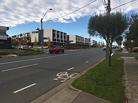
| Alphington Melbourne, Victoria | |||||||||||||||
|---|---|---|---|---|---|---|---|---|---|---|---|---|---|---|---|
 Heidelberg Road, Alphington | |||||||||||||||
 | |||||||||||||||
| Coordinates | 37°46′48″S 145°01′23″E / 37.780°S 145.023°E | ||||||||||||||
| Population | 5,702 (2021 census)[1] | ||||||||||||||
| • Density | 2,040/km2 (5,270/sq mi) | ||||||||||||||
| Postcode(s) | 3078 | ||||||||||||||
| Elevation | 37 m (121 ft) | ||||||||||||||
| Area | 2.8 km2 (1.1 sq mi) | ||||||||||||||
| Location | 7 km (4 mi) NE of Melbourne | ||||||||||||||
| LGA(s) | |||||||||||||||
| State electorate(s) | Northcote | ||||||||||||||
| Federal division(s) | Cooper | ||||||||||||||
| |||||||||||||||
Alphington (/ælfɪŋtən/ ALF-ing-tən) is a suburb in Melbourne, Victoria, Australia, 7 km (4.3 mi) north-east of Melbourne's Central Business District, located within the Cities of Darebin and Yarra local government areas. Alphington recorded a population of 5,702 at the 2021 census.[1]
Alphington shares a postcode with neighbouring suburb Fairfield,[2] and is bounded by the Yarra River in the south and the Darebin Creek in the east.
- ^ a b Australian Bureau of Statistics (28 June 2022). "Alphington (Suburbs and Localities)". 2021 Census QuickStats. Retrieved 2 July 2022.
- ^ "ALPHINGTON Postcode (VIC)".
