| Altamaha River | |
|---|---|
 The Altamaha River viewed from the bridge between Glynn County and McIntosh County, Georgia, USA | |
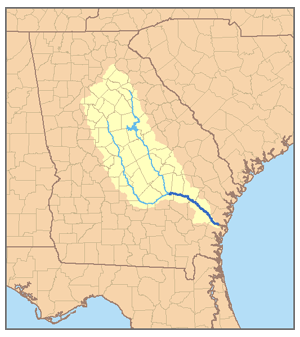
 Map of the Altamaha River watershed showing the two main tributaries, the Ocmulgee River and the Oconee River | |
| Location | |
| Country | United States |
| State | Georgia |
| Physical characteristics | |
| Source | near Hazlehurst |
| • location | Georgia |
| • coordinates | 31°57′33″N 82°32′37″W / 31.95917°N 82.54361°W[1] |
| • elevation | 82 ft (25 m)[2] |
| Mouth | Atlantic Ocean |
• location | Altamaha Sound |
• coordinates | 31°18′57″N 81°17′5″W / 31.31583°N 81.28472°W[1] |
• elevation | 0 ft (0 m)[2] |
| Length | 137 mi (220 km)[3] |
| Basin size | 14,000 sq mi (36,000 km2)[4] |
| Discharge | |
| • location | Doctortown, GA[5] |
| • average | 13,520 cu ft/s (383 m3/s)[5] |
| • minimum | 1,410 cu ft/s (40 m3/s) |
| • maximum | 178,000 cu ft/s (5,000 m3/s) |
| Basin features | |
| Tributaries | |
| • left |
|
| • right |
|
The Altamaha River /ˈɑːltəməhɑː/ is a major river in the U.S. state of Georgia. It flows generally eastward for 137 miles (220 km) from its origin at the confluence of the Oconee River and Ocmulgee River towards the Atlantic Ocean, where it empties into the ocean near Brunswick, Georgia. No dams are directly on the Altamaha, though some are on the Oconee and the Ocmulgee. Including its tributaries, the Altamaha River's drainage basin is about 14,000 square miles (36,000 km2) in size, qualifying it among the larger river basins of the US Atlantic coast.[3]
- ^ a b U.S. Geological Survey Geographic Names Information System: Altamaha River
- ^ a b Google Earth elevation for GNIS coordinates.
- ^ a b The Altamaha River Archived 2007-09-27 at the Wayback Machine
- ^ Cite error: The named reference
georgiawas invoked but never defined (see the help page). - ^ a b Water Data Report, Georgia 2004, USGS