Native name: 奄美群島 Amami-guntō | |
|---|---|
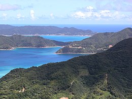
 Coast of Amami Oshima | |
 | |
| Geography | |
| Coordinates | 28°16′N 129°21′E / 28.267°N 129.350°E |
| Adjacent to | Pacific Ocean |
| Total islands | 8 (inhabited) |
| Area | 1,240.28 km2 (478.87 sq mi) |
| Highest elevation | 694 m (2277 ft) |
| Highest point | Yuwandake |
| Administration | |
Japan | |
| Prefectures | Kagoshima |
| Demographics | |
| Population | 104,281 (2020) |
| Ethnic groups | Ryukyuan, Japanese |

The Amami Islands (奄美群島, Amami-guntō)[1] is an archipelago in the Satsunan Islands, which is part of the Ryukyu Islands, and is southwest of Kyushu. Administratively, the group belongs to Kagoshima Prefecture, Japan. The Geospatial Information Authority of Japan and the Japan Coast Guard agreed on February 15, 2010, to use the name of Amami-guntō (奄美群島) for the Amami Islands. Prior to that, Amami-shotō (奄美諸島) was also used.[2] The name of Amami is probably cognate with Amamikyu (阿摩美久), the goddess of creation in the Ryukyuan creation myth.
- ^ The name Amami-guntō was standardized on February 15, 2010."『奄美群島』を決定地名に採用". Geospatial Information Agency of Japan. Archived from the original on 31 July 2012. Retrieved 23 November 2011. Prior to that, another name, Amami shotō (奄美諸島), was also used.
- ^ "『奄美群島』を決定地名に採用". Geospatial Information Agency of Japan. Archived from the original on 31 July 2012. Retrieved 23 November 2011.