Amarapura
အမရပူရ | |
|---|---|
Township of Mandalay | |
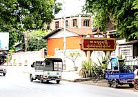
 Entrance of Amarapura town | |
| Coordinates: 21°54′N 96°03′E / 21.900°N 96.050°E | |
| Country | |
| Region | |
| District | Amarapura |
| Township | Amarapura |
| Founded | 13 May 1783 |
| Time zone | UTC6:30 (MST) |
| Area codes | 2 (mobile: 69, 90)[1] |
Amarapura ([အမရပူရ] Error: {{Langx}}: invalid parameter: |MLCTS= (help), pronounced [ʔəməɹa̰pùɹa̰], lit. 'The Immortal city'; also spelt as Ummerapoora[2]) is a former capital of Myanmar, and now a township of Mandalay city. Amarapura is bounded by the Irrawaddy river in the west, Chanmyathazi Township in the north, and the ancient capital site of Ava (Inwa) in the south. It was the capital of Myanmar twice during the Konbaung period (1783–1821 and 1842–1859) before finally being supplanted by Mandalay 11 kilometres (6.8 mi) north in 1859. It is historically referred to as Taungmyo (Southern City) in relation to Mandalay. Amarapura today is part of Mandalay, as a result of urban sprawl. The township is known today for its traditional silk and cotton weaving, and bronze casting. It is a popular tourist day-trip destination from Mandalay.
- ^ "Myanmar Area Codes". Archived from the original on 2009-12-01. Retrieved 2009-04-04.
- ^ Arrowsmith, Aaron (1831). A compendium of ancient and modern geography. London, England. p. 637.
