| Amargosa River | |
|---|---|
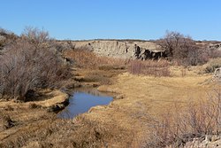
 Amargosa River at Tecopa, California | |
| Etymology | Spanish word for "bitter" |
| Location | |
| Country | United States |
| State | Nevada, California |
| County | Nye, San Bernardino, and Inyo |
| Physical characteristics | |
| Source | Pahute Mesa |
| • location | Oasis Valley, Nye County, Nevada |
| • coordinates | 37°04′20″N 116°41′19″W / 37.07222°N 116.68861°W[1] |
| • elevation | 3,964 ft (1,208 m)[2] |
| Mouth | Death Valley |
• location | Badwater Basin, Inyo County, California |
• coordinates | 36°14′37″N 116°51′24″W / 36.24361°N 116.85667°W[1] |
• elevation | −282 ft (−86 m)[3] |
| Length | 185 mi (298 km)[1] |
| Basin size | 5,500 sq mi (14,000 km2)[4] |
| Discharge | |
| • location | 0.2 miles (0.3 km) west of Tecopa[5] |
| • average | 3.8 cu ft/s (0.11 m3/s)[5] |
| • minimum | 0 cu ft/s (0 m3/s) |
| • maximum | 10,600 cu ft/s (300 m3/s) |
| Type | Wild, Scenic, Recreational |
| Designated | March 30, 2009 |
The Amargosa River is an intermittent waterway, 185 miles (298 km) long, in southern Nevada and eastern California in the United States. The Amargosa River is one out of two rivers located in the California portion of the Mojave Desert with perennial flow.[6] It drains a high desert region, the Amargosa Valley in the Amargosa Desert northwest of Las Vegas, into the Mojave Desert, and finally into Death Valley where it disappears into the ground aquifer. Except for a small portion of its route in the Amargosa Canyon in California and a small portion at Beatty, Nevada, the river flows above ground only after a rare[quantify] rainstorm washes the region. A 26-mile (42 km) stretch of the river between Shoshone and Dumont Dunes is protected as a National Wild and Scenic River. At the south end of Tecopa Valley the Amargosa River Natural Area protects the habitat.
- ^ a b c "Amargosa River". Geographic Names Information System. United States Geological Survey. January 19, 1981. Retrieved February 23, 2009.
- ^ Source elevation derived from Google Earth search using GNIS source coordinates.
- ^ "Highest and Lowest Elevations". United States Geological Survey. Retrieved April 29, 2021.
- ^ Tanko, Daron J.; Glancy, Patrick A. (2001). "Fact Sheet 036-01: Flooding in the Amargosa River Drainage Basin, February 23–24, 1998, Southern Nevada and Eastern California, including the Nevada Test Site". United States Geological Survey. Retrieved February 24, 2009.
- ^ a b "Water-data report 2007: 10251300 Amargosa River at Tecopa, CA" (PDF). United States Geological Survey. Retrieved February 24, 2009.
- ^ Parker, Sophie; Moore, Jim; Warren, Leonard (April 2018). "Ecological Values of the Amargosa River in California" (PDF). The Nature Conservancy.
