| Amga | |
|---|---|
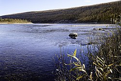
 Amga River near Verkhnyaya Amga | |
Location in the Sakha Republic, Russia | |
| Location | |
| Country | Russia |
| Physical characteristics | |
| Source | |
| • location | Aldan Highlands |
| Mouth | Aldan |
• coordinates | 62°37′41″N 134°55′11″E / 62.6281°N 134.9197°E |
| Length | 1,462 km (908 mi) |
| Basin size | 69,300 km2 (26,800 sq mi) |
| Discharge | |
| • average | 178 m3/s (6,300 cu ft/s) |
| Basin features | |
| Progression | Aldan→ Lena→ Laptev Sea |
The Amga (Russian: Амга; Yakut: Амма, Amma) is a river in Sakha (Yakutia), Russia. The length of the river is 1,462 kilometres (908 mi). The area of its basin is 69,300 square kilometres (26,800 sq mi).[1] The Amga freezes up in the first half of October and stays under the ice until May. Many different kinds of Fish can be found in the Amga river.
- ^ "Река АМГА in the State Water Register of Russia". textual.ru (in Russian).
