Amnat Charoen
อำนาจเจริญ | |
|---|---|
 Phra Mongkol Ming Mueang | |
| Motto(s): พระมงคลมิ่งเมือง แหล่งรุ่งเรืองเจ็ดลุ่มน้ำ งามล้ำถ้ำศักดิ์สิทธิ์ เทพนิมิตพระเหลา เกาะแก่งเขาแสนสวย เลอค่าด้วยผ้าไหม ราษฎร์เลื่อมใสใฝ่ธรรม ("Phra Mongkhon Ming Mueang. The source of seven great streams. Beautiful, sacred caves. Holy Buddha amulets, Beautiful rapids and mountains. Precious silk. Righteous people believing in Dharma.") | |
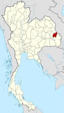
 Map of Thailand highlighting Amnat Charoen province | |
| Country | Thailand |
| Capital | Amnat Charoen |
| Government | |
| • Governor | Thaweep Butpho (since October 2020)[1] |
| Area | |
| • Total | 3,290 km2 (1,270 sq mi) |
| • Rank | Ranked 59th |
| Population (2019)[3] | |
| • Total | 378,438 |
| • Rank | Ranked 65th |
| • Density | 115/km2 (300/sq mi) |
| • Rank | Ranked 44th |
| Human Achievement Index | |
| • HAI (2022) | 0.6549 "somewhat high" Ranked 20th |
| GDP | |
| • Total | baht 18 billion (US$0.6 billion) (2019) |
| Time zone | UTC+7 (ICT) |
| Postal code | 37xxx |
| Calling code | 045 |
| ISO 3166 code | TH-37 |
| Website | www |
Amnat Charoen (Thai: อำนาจเจริญ, pronounced [ʔām.nâːt tɕā.rɤ̄ːn]; Northeastern Thai: อำนาจเจริญ, pronounced [ʔām.nâːt tɕā.lɤ᷇ːn]) is one of Thailand's seventy-six provinces (changwat) and lies central northeastern Thailand, also called Isan. Neighbouring provinces are (clockwise from the south) Ubon Ratchathani, Yasothon, and Mukdahan. To the east it borders Salavan of Laos. Its name is a concatenation of อำนาจ ("authority, power") and เจริญ ("prosperous").[6]
- ^ "ประกาศสำนักนายกรัฐมนตรี เรื่อง แต่งตั้งข้าราชการพลเรือนสามัญ" [Announcement of the Prime Minister's Office regarding the appointment of civil servants] (PDF). Royal Thai Government Gazette. 137 (Special 194 Ngor). 35. 21 August 2020. Archived from the original (PDF) on August 25, 2020. Retrieved 13 April 2021.
- ^ "ตารางที่ 2 พี้นที่ป่าไม้ แยกรายจังหวัด พ.ศ.2562" [Table 2 Forest area Separate province year 2019]. Royal Forest Department (in Thai). 2019. Retrieved 6 April 2021, information, Forest statistics Year 2019, Thailand boundary from Department of Provincial Administration in 2013
{{cite web}}: CS1 maint: postscript (link) - ^ รายงานสถิติจำนวนประชากรและบ้านประจำปี พ.ส.2562 [Statistics, population and house statistics for the year 2019]. Registration Office Department of the Interior, Ministry of the Interior. stat.bora.dopa.go.th (in Thai). 31 December 2019. Archived from the original on 14 June 2019. Retrieved 26 February 2020.
- ^ "ข้อมูลสถิติดัชนีความก้าวหน้าของคน ปี 2565 (PDF)" [Human Achievement Index Databook year 2022 (PDF)]. Office of the National Economic and Social Development Council (NESDC) (in Thai). Retrieved 12 March 2024, page 86
{{cite web}}: CS1 maint: postscript (link) - ^ "Gross Regional and Provincial Product, 2019 Edition". <>. Office of the National Economic and Social Development Council (NESDC). July 2019. ISSN 1686-0799. Retrieved 22 January 2020.
- ^ Cite error: The named reference
ThaiLexwas invoked but never defined (see the help page).

