| Anabar Plateau | |
|---|---|
| Анабарское плато | |
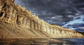
 Cliffs by the Kotuykan River, Anabar Plateau | |
| Highest point | |
| Peak | unnamed |
| Elevation | 905 m (2,969 ft) |
| Dimensions | |
| Length | 550 km (340 mi) |
| Width | 370 km (230 mi) |
| Geography | |
Location in Krasnoyarsk Krai, Russia | |
| Country | Russia |
| Federal subject | Krasnoyarsk Krai and Sakha Republic |
| Range coordinates | 70°30′N 108°0′E / 70.500°N 108.000°E |
| Parent range | Central Siberian Plateau |
| Geology | |
| Rock age(s) | Archean, Proterozoic and Lower Paleozoic |
| Rock type(s) | Gneiss, schist and Limestone |
The Anabar Plateau (Russian: Анабарское плато) is a mountain plateau in Krasnoyarsk Krai and the Sakha Republic (Yakutia), Siberia, Russia.
The plateau is in a latitude dominated by permafrost. The permafrost thickness under the Anabar Plateau reaches 1,400 metres (4,600 ft).[1]
