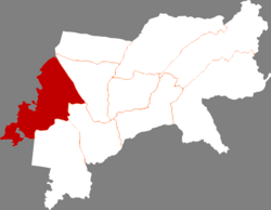
Anda
安达市 An-ta | |
|---|---|
 Location of Anda City within Suihua | |
| Coordinates: 46°25′26″N 125°21′07″E / 46.424°N 125.352°E | |
| Country | People's Republic of China |
| Province | Heilongjiang |
| Prefecture-level city | Suihua |
| Township-level divisions | 4 subdistricts 10 towns 4 township |
| Area | |
| • Total | 3,586.3 km2 (1,384.7 sq mi) |
| Elevation | 149 m (489 ft) |
| Population | |
| • Total | 472,826 |
| • Density | 130/km2 (340/sq mi) |
| Time zone | UTC+8 (China Standard) |
| Postal code | 151400 |
| Area code | 0455 |
| Climate | Dwa |
| Website | www |
Anda (simplified Chinese: 安达; traditional Chinese: 安達; pinyin: Āndá) is a county-level city in western Heilongjiang province, People's Republic of China, located on the Harbin-Manzhouli Railway (formerly known as the Chinese Eastern Railway) about 30 kilometres (19 mi) southeast of Daqing and 110 km (68 mi) northwest of Harbin, capital of Heilongjiang, and is under the administration of Suihua City. Home to China's forage and dairy industries, more than 1,814 km2 (700 sq mi) out of Anda's 3,586 km2 (1,385 sq mi) total area is made up of grasslands.
