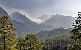
Anjaw district | |
|---|---|
Lohit river and Kibithu | |
 Location in Arunachal Pradesh | |
| Country | |
| State | Arunachal Pradesh |
| Headquarters | Hawai |
| Government | |
| • Lok Sabha constituencies | Arunachal East |
| • Vidhan Sabha constituencies | Hayuliang |
| Area | |
| • Total | 6,190 km2 (2,390 sq mi) |
| Population (2011) | |
| • Total | 21,167 |
| • Density | 3.4/km2 (8.9/sq mi) |
| Demographics | |
| • Literacy | 59.4% |
| • Sex ratio | 805 |
| Time zone | UTC+05:30 (IST) |
| Website | anjaw |
Anjaw District (Pron:/ˈændʒɔ:/) is an administrative district in the state of Arunachal Pradesh in north-east India. It was created as a district in 2004, by splitting off from the Lohit district under the Arunachal Pradesh Re-organization of Districts Amendment Act.[1] The district borders China on the north. Hawai, at an altitude of 1296 m above sea level, is the district headquarters, located on the banks of the Lohit River, a tributary of the Brahmaputra River. Anjaw is the easternmost district in India.[2] The furthest villages towards the border with China are Dong,[3] Walong, Kibithu and Kaho.

Anjaw is the second least populous district in India (out of 640).[citation needed]
- ^ Law, Gwillim (25 September 2011). "Districts of India". Statoids. Retrieved 11 October 2011.
- ^ "Anjaw District". Archived from the original on 14 November 2006. Retrieved 27 October 2006.
- ^ Gokhale, Nitin A. (20 August 2001). "Dong". Outlook India. Retrieved 16 December 2012.


