| Annan | |
|---|---|
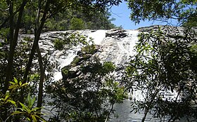
 A waterfall in the Upper Annan River catchment | |
Location of Annan River mouth in Queensland | |
| Etymology | River Annan, Scotland[1] |
| Native name | Yuku Baja (Kuku Nyungkal) |
| Location | |
| Country | Australia |
| State | Queensland |
| Region | Far North Queensland, Wet Tropics of Queensland |
| Physical characteristics | |
| Source | Yorkey Range |
| • location | below Mount Romeo |
| • coordinates | 15°50′13″S 145°17′26″E / 15.83694°S 145.29056°E |
| • elevation | 568 m (1,864 ft) |
| Mouth | Walker Bay, Coral Sea |
• location | south of Cooktown |
• coordinates | 15°31′49″S 145°16′25″E / 15.53028°S 145.27361°E |
• elevation | 0 m (0 ft) |
| Length | 66 km (41 mi) |
| Basin size | 750 km2 (290 sq mi) |
| Discharge | |
| • location | Near mouth |
| • average | 26.6 m3/s (840 GL/a)[2] |
| Basin features | |
| Tributaries | |
| • left | Scrubby Creek, Oaky Creek (Queensland) |
| • right | Trevethan Creek |
| National parks | Kalkajaka National Park; Annan River (Yuku Baja-Muliku) National Park |
| [3][4][5][6] | |
The Annan River (Kuku Nyungkal: Yuku Baja[7]) is a river in the Wet Tropics of Far North Queensland, Australia.
- ^ Cite error: The named reference
qpnwas invoked but never defined (see the help page). - ^ "East Coastal Watersheds".
- ^ "Map of Annan River, QLD". Bonzle Digital Atlas of Australia. Retrieved 23 October 2015.
- ^ "Map of Annan River (1), QLD". Bonzle Digital Atlas of Australia. Retrieved 23 October 2015.
- ^ "Water resources – Overview – Queensland – Basin & Surface Water Management Area: Endeavour River". Australian Natural Resources Atlas. Department of the Environment, Water, Heritage and the Arts. Archived from the original on 28 July 2008. Retrieved 24 February 2009.
- ^ Davies, P. L.; Eyre, B. D. (2005). "Estuarine modification of nutrient and sediment exports to the Great Barrier Reef Marine Park from the Daintree and Annan River catchments" (PDF). Marine Pollution Bulletin. 51 (1–4): 174–185. doi:10.1016/j.marpolbul.2004.11.008. PMID 15757719. Retrieved 24 February 2009.[permanent dead link]
- ^ Bama Way (PDF) (Map). 2014. Archived from the original (PDF) on 26 February 2015. Retrieved 13 March 2009.
