| Anticosti National Park | |
|---|---|
| Parc National d'Anticosti | |
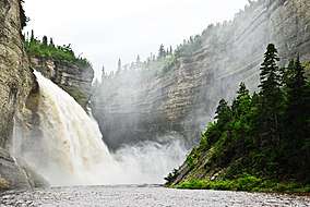
 Cliff wall, fall and Vauréal River[1] | |
| Location | Quebec, Canada |
| Nearest city | Port-Menier, Quebec |
| Coordinates | 49°30′N 62°50′W / 49.500°N 62.833°W |
| Area | 571.9 km2 (220.8 sq mi) |
| Established | April 2001 |
| Visitors | 5500 (in 2009) |
| Governing body | Sépaq |
| www | |
 | |
Anticosti National Park (French (official): Parc National d'Anticosti) is a provincial park of Quebec, located in the Gulf of St. Lawrence.[2][3] It consists of 3 non-contiguous areas totalling 572 square kilometres (221 sq mi) of land in the centre of Anticosti Island. Portions of the park are within Anticosti World Heritage site.
- ^ "Vauréal canyon". Commission de toponymie Quebec (in French). Commission de Toponymy Quebec. 1984-10-04. Retrieved 29 July 2024.
... 3 kilometer canyon, whose walls can reach more than 90 meters in height
- ^ "Protected areas in Quebec" (in French). Ministère de l'Environnement, de la Lutte contre les changements climatiques, de la Faune et des Parcs. 2024. Retrieved 13 August 2024.
Protected areas are also recognized as an essential tool for adaptation to climate change. In particular, they allow carbon to be stored.
- ^ "Map of protected areas in Quebec" (PDF) (in French). Environment and Climate Change Canada. March 2024. Retrieved 13 August 2024.
Protected areas register database, 2024 Ministry of Environment and Ecological reference framework, 2018 adapted
