This article needs additional citations for verification. (March 2023) |
Anupgarh district | |
|---|---|
 View of canal in tehsil Rawla Mandi of Anupgarh district | |
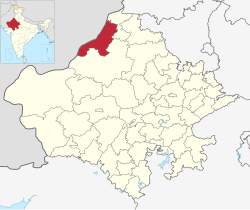
 Location of Anupgarh district in Rajasthan | |
| Coordinates (Anupgarh district headquarters): 29°11′22″N 73°12′30″E / 29.18944°N 73.20833°E | |
| Country | |
| State | Rajasthan |
| Division | Bikaner |
| Established | 7 August 2023 |
| Headquarters | Anupgarh |
| Tehsils | Raisinghnagar Anupgarh Sri Vijaynagar Gharsana Rawla Mandi |
| Government | |
| • Type | State Government |
| • Body | Government of Rajasthan |
| • District Magistrate | Avdhesh Meena, IAS[1] |
| • Superintendent of Police | Rajendra Kumar, IPS |
| Area | |
• Total | 4,713.96 km2 (1,820.07 sq mi) |
| Population (2011)[2] | |
• Total | 698,478 |
| • Density | 150/km2 (380/sq mi) |
| Demographics [2] | |
| • Literacy | 58.18 % |
| • Sex ratio | 899/1000 |
| Languages | |
| • Official | Hindi[3] |
| • Additional_official | English[3] |
| • Most spoken | Punjabi, Bagri, Rajasthani |
| Time zone | UTC+05:30 (IST) |
| Major highways | RJ SH 3 |
| Website | official website |
Anupgarh district is a new north-west district of Rajasthan state in India. It was established on 7 August 2023 after curving it out of Sri Ganganagar District.
- ^ "Anupgarh - District Administration". Government of Rajathan. Retrieved 25 February 2024.
- ^ a b "Ganganagar District Population, Rajasthan, List of Tehsils in Ganganagar".
- ^ a b "Report of the Commissioner for linguistic minorities: 52nd report (July 2014 to June 2015)" (PDF). Commissioner for Linguistic Minorities, Ministry of Minority Affairs, Government of India. pp. 34–35. Archived from the original (PDF) on 28 December 2017. Retrieved 16 February 2016.