Aoukar
عوكر | |
|---|---|
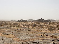
 Landscape in the Ayoun el Atrous area | |
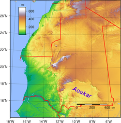
 Location of the Aoukar basin in Mauritania | |
| Country | Mauritania |
| Elevation | 240 m (790 ft) |
Aoukar or Erg Aoukar[1] (Arabic: عوكر) is a geological depression area of south eastern Mauritania. It is located between Kiffa and Néma, south of the Tagant Plateau. The region is also referred to as Hodh or El Hodh[5] (Arabic: الحوض, lit. 'the Basin').[3]
The Aoukar basin is a dry natural region of sand dunes and salt pans fringed by escarpments on its northern and eastern sides.
- ^ Marco Stoppato, Alfredo Bini (2003), Deserts, p. 156
- ^ Fāsī, Muḥammad & al. General History of Africa, Vol. III: Africa from the Seventh to the Eleventh Century, p. 130. UNESCO (Paris), 1988. Accessed 18 Apr 2014.
- ^ a b Barth, Henry. Travels and Discoveries in North and Central Africa, being a Journal of an Expedition undertaken under the Auspices of H.B.M.'s Government, in the Years 1849–1855, Vol. 3, pp. 712 ff. Harper & Bros. (New York), 1859. Accessed 18 Apr 2014.
- ^ Ould-Mey, Mohameden. Global Restructuring and Peripheral States: The Carrot and the Stick in Mauritania, p. 66. Rowman & Littlefield (Lanham), 1996. Accessed 18 Apr 2014.
- ^ Also encountered as Hōdh, Ḥawḍ,[2] Hódh,[3] and al-Hodh.[4]