Appomattox Court House National Historical Park | |
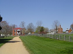
 Appomattox Court House National Historical Park. The Old Appomattox Court House is at left; the reconstructed McLean House, the site of the formal surrender, is at right. | |
| Location | Appomattox County, Virginia |
|---|---|
| Nearest city | Appomattox, Virginia |
| Coordinates | 37°22′39″N 78°47′45.6″W / 37.37750°N 78.796000°W |
| Area | 1,774.6 acres (718.2 ha)[2] |
| Visitation | 92,650 (2021)[3] |
| Website | Appomattox Court House National Historical Park |
| NRHP reference No. | 66000827[1] |
| VLR No. | 006-0033[4] |
| Significant dates | |
| Added to NRHP | October 15, 1966 |
| Designated VLR | July 6, 1971[4] |
The Appomattox Court House National Historical Park is the preserved 19th-century village named Appomattox Court House in Appomattox County, Virginia. The village was named for the presence nearby of what is now preserved as the Old Appomattox Court House. The village is the site of the Battle of Appomattox Court House, and contains the McLean House, where the surrender of the Army of Northern Virginia under Robert E. Lee to Union commander Ulysses S. Grant took place on April 9, 1865, an event widely symbolic of the end of the American Civil War. The village itself began as the community of Clover Hill, which was made the county seat of Appomattox County in the 1840s. The village of Appomattox Court House entered a stage of decline after it was bypassed by a railroad in 1854. In 1930, the United States War Department was authorized to erect a monument at the site, and in 1933 the War Department's holdings there was transferred to the National Park Service. The site was greatly enlarged in 1935, and a restoration of the McLean House was planned but was delayed by World War II. In 1949, the restored McLean House was reopened to the public. Several restored buildings (including the McLean House and the courthouse), as well as a number of original 19th-century structures are situated at the site.
- ^ National Register of Historic Places 66000827 National Park Service. Retrieved May 28, 2020.
- ^ "Listing of acreage – December 31, 2022" (XLSX). Land Resource Division, National Park Service. Retrieved January 26, 2023. (National Park Service Acreage Reports)
- ^ "Appomattox Court House NHP". irma.nps.gov. National Park Service. Retrieved January 26, 2023.
- ^ a b "006-0033 Appomattox Court House". Virginia Department of Historic Resources. Retrieved January 26, 2023.

