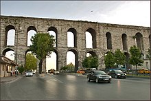
Aqueduct of Valens Bozdoğan Kemeri | |
|---|---|
 Aqueduct of Valens | |
| Coordinates | 41°00′57.4″N 28°57′20″E / 41.015944°N 28.95556°E |
| Carries | Aqueduct of Valens to Constantinople |
| Crosses | Atatürk Boulevard |
| Locale | Istanbul, Turkey |
| Characteristics | |
| Design | Aqueduct bridge |
| Material | Stone, brick |
| Total length | Originally 971 m (3,186 ft) |
| Width | 7.75–8.24 m (25.4–27.0 ft) |
| Height | Ca. 29 m (95 ft) |
| Longest span | Ca. 4 m (13 ft) |
| History | |
| Construction end | 368 AD |
| Location | |
 | |
The Aqueduct of Valens (Turkish: Valens Su Kemeri, Ancient Greek: Ἀγωγὸς τοῦ ὕδατος, romanized: Agōgós tou hýdatos, lit. 'aqueduct') was a Roman aqueduct system built in the late 4th century AD, to supply Constantinople – the capital of the Eastern Roman Empire. Construction of the aqueduct began during the reign of the Roman emperor Constantius II (r. 337–361) and was completed in 373 by the Emperor Valens (r. 364–378). The aqueduct remained in use for many centuries. It was extended and maintained by the Byzantines and the Ottomans.
Initially, the Aqueduct of Valens carried water from springs at Danımandere and Pınarca; the channels from each spring met at Dağyenice. This 4th-century first phase of the system was 268 kilometres (167 miles) long.[1] A second, 5th-century phase added a further 451 kilometres (280 miles) of conduits that took water from Vize, 120 kilometres (75 miles) away from Constantinople.[1][2]: 13
The final and most visible aqueduct bridge in the system survives in the Fatih district of Istanbul, Turkey. Named in Turkish: Bozdoğan Kemeri, lit. 'Aqueduct of the Grey Falcon', it is an important landmark in the city, with its arches passing over Atatürk Boulevard (Atatürk Bulvarı). The Bozdoğan Kemeri spans the valley between the hills that are today occupied by the Istanbul University and the Fatih Mosque, formerly the site of the Church of the Holy Apostles. The surviving section is 921 metres long, about 50 metres less than the original length.[3]


- ^ a b Crow, Jim (28 March 2012). "Ruling the waters: managing the water supply of Constantinople, AD 330–1204". Water History. 4 (1): 35–55. doi:10.1007/s12685-012-0054-y. ISSN 1877-7244. S2CID 162261784.
- ^ Mango, Cyril (1995). "The Water Supply of Constantinople". In Mango, Cyril; Dagron, Gilbert; Greatrex, Gregory (eds.). Constantinople and Its Hinterland: Papers from the Twenty-seventh Spring Symposium of Byzantine Studies, Oxford, April 1993. Society for the Promotion of Byzantine Studies Publications 3. Aldershot: Variorum. pp. 9–18. doi:10.4324/9781315259567. ISBN 9781351949439.
- ^ Mamboury (1953), p. 196.